Ametlla de Mar to Ampolla GR‑92 Coastal Walk – Costa Dorada
17 km medium‑difficulty GR‑92 coastal walk from L’Ametlla de Mar to L’Ampolla, passing unspoilt coves, pine‑backed beaches and some of the wildest coastline on the Costa Dorada
Views:
2.7k
About Ametlla De Mar To Ampolla Costa Dorada Walk
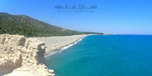
This section of the Costa Dorada is perfect for anyone who wants a coastal walk that still feels wild. Between L’Ametlla de Mar and l’Ampolla, the GR‑92 winds through rocky coves, pine forests and untouched beaches with almost no signs of hotels or heavy development. It’s one of the most natural stretches of coastline in southern Catalonia, where the path hugs the cliffs, the sea stays in view for nearly the entire day, and the soundtrack is waves, cicadas and wind in the pines.
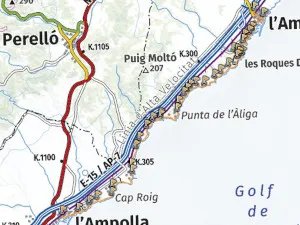
The route is a spectacular 17 km linear walk starting at L'Ametlla de Mar RENFE station and ending at l'Ampolla–El Perelló–Deltebre on the Regional train network, south of Tarragona. The train journey from Barcelona takes around two hours.
It follows the GR‑92 Mediterranean coastal trail, marked periodically by white and red paint stripes on trees, rocks and in the towns, guiding you through a chain of small coves and beaches that remain largely untouched by human activity.
L’Ametlla de Mar town
L’Ametlla de Mar has a very different energy from the resort towns further north — it still feels like a working Mediterranean fishing village first, and a holiday destination second. The harbour is the heart of the town, with fishing boats heading out at dawn and returning in the afternoon, giving the place a rhythm that hasn’t changed much in decades. Narrow streets, whitewashed houses and small family‑run bars give it a lived‑in, authentic feel that many coastal towns have lost.
Historically, L’Ametlla grew around its natural coves and sheltered inlets, which made it an ideal base for fishermen long before tourism arrived. The coastline here is rugged and fractured, dotted with tiny natural ports like l’Estany d’en Gras where boats once moored directly against the rocks. Even today, the town’s identity is tied closely to the sea — from its seafood traditions to the small-scale fishing fleet that still operates daily.
The vibe is relaxed, maritime and slightly wild around the edges. As soon as you leave the town limits, the landscape becomes almost untouched: pine forests, rocky headlands and coves that feel far removed from the built‑up Costa Dorada. It’s this blend of authentic fishing‑town character and raw natural coastline that makes L’Ametlla de Mar such a memorable starting point.
L’Ampolla town
L’Ampolla has a completely different personality from L’Ametlla — softer, more open, and unmistakably shaped by its role as a small seaside resort. The town curves gently around a series of sandy beaches and calm bays, giving it a laid‑back holiday vibe that feels welcoming without being overdeveloped. Promenades lined with cafés, family‑run restaurants and palm trees make it an easy place to unwind.
Unlike L’Ametlla de Mar, where the harbour still revolves around daily fishing activity, L’Ampolla’s port has evolved into a modern marina for pleasure craft. The shift gives the town a lighter, more resort‑oriented feel — sailboats, waterfront terraces and calm beaches shaping the rhythm of daily life. It’s a natural transition point where the rugged GR‑92 coastline begins to soften and open out toward the vast landscapes of the Delta de l’Ebre natural park.
Image Gallery For Ametlla De Mar To Ampolla Costa Dorada Walk
Click on any of the 66 images to open full screen gallery player. Note that viewing images is subject to our Fair Use Policy.
Visiting Ametlla De Mar To Ampolla Costa Dorada Walk
After exiting L'Ametlla de Mar RENFE station, take Carrer Pau Casals towards the coast to reach Plaça de Joan Miró, a balconied square overlooking Playa Alghero. Txemari Bar Restaurant is an excellent place to get breakfast and a coffee before starting the walk.
From here, follow the road around the coastline and along the port of L'Ametlla de Mar. At the southern end of the harbour, where the road meets Carrer Mediterrani and Carrer Cala Pepo, take the footpath towards Cala Pepo and continue along the coastline behind the houses. This path passes the small beaches of Platja de Ribes Altes, Cala Bon Caponet and Cala Bon Capó, including a Roman embarkation point carved directly into the rocks.
Soon you will reach the Port Natural de l'Estany d’en Gras, a natural harbour where fishermen once moored their boats before the main port was built in the 1920s. Follow the path along the side of the inlet, where you can still see old steel mooring eyelets. Continue past the stone house covered in flowers until you reach a line of boulders that allow you to cross the water. Follow the road beside the natural port and walk across Platja de l'Estany.
When the road bends inland, continue straight along the coastal path. You’ll pass several old fortifications hidden among the trees before arriving at Cala Port Olivet — one of the most beautiful coves on the route and a perfect place for a swim. After leaving the beach, continue along the shoreline path.
At Cala Santes Creus you’ll find a pristine cove with a lagoon behind it and a rocky headland. This is another excellent swimming spot, with shallow sea caves on the southern side. When ready, follow the path around the headland for spectacular views of Platja de la Llenya.
The trail continues parallel to the coast along sea cliffs and through pine forest until you reach the stony beach of Platja de l'Estany Podrit. Leave the beach via the ascending forest path and continue along rocky shoreline trails.
You’ll soon get views of Platja de l’Illot, where a rocky islet is connected to the shore by two small hidden beaches accessible via steep descending paths. Continue along the coastline to Platja de l’Àliga. I don’t recommend swimming here, as the cove is often busy with noisy jet skis.
Leave the beach by following the road uphill and rejoining the GR‑92 as it returns to the pine forest, eventually reaching Platja de Cala Moros — another good swimming option. The trail then continues along rocky cliffs and past more small coves, including Platja de Racó de Garretes, Platja de la Dolç del Me and Platja Santa Llúcia.
At Morro de Gos beach you’ll find Xiringuito Morro de Gos, a great place to stop for snacks, tapas and a refreshing swim before the final stretch.
Continue along the coastal trail around the Mirador Cap Roig headland and onto Platja de Cap Roig. Use the road behind the beach to climb onto the trail across the Punta de Pinyana headland, passing a clifftop hotel and returning to lighter, more natural vegetation.
Cross Platja Cala Maria and follow the trail to Platja del Baconé, then Playa de Capellans and finally Platja de les Avellanes, the last beach on the route. From here, follow the road into town and around the marina. The train station is on Carrer Bassa de Fornós, next to a terrace bar by the railway bridge.
Allow 6–9 hours to complete the route depending on how much time you spend swimming. Between the two towns there is almost no civilisation, and all beaches are without lifeguards or beach bars, so carry at least 3 litres of water per person and take care when swimming.
Hiking the Costa Dorada La Ronda Ametlla de Mar to Ampolla with a Dog
Dogs are generally not permitted on beaches during the summer season (1st June to the last Sunday in September), except in designated dog zones. This route includes many beaches that are not dog‑friendly in summer, so it’s best completed with your dog outside the restricted period.
Halfway along the route you’ll find one exception: Playa de Bon Caponet, a 50‑metre‑wide beach where dogs are allowed to swim in summer.
For a fully dog‑friendly experience, complete this route outside the summer restrictions (1st June to the last Sunday of September). The best months are October to May, which you can also find in the Dog Hiking Calendar.
The walk combines long sandy beaches, rocky coastal paths and shaded pine forest trails. In spring and early autumn, be aware of pine processionary caterpillars, which are dangerous to dogs if touched or inhaled. Aside from this seasonal hazard, the route is suitable for most dogs and offers plenty of natural shade and soft terrain.
What to take with you for Ametlla De Mar To Ampolla Costa Dorada Walk
Because this route involves long stretches of beach walking and several points where you’ll be close to the shoreline, it’s worth protecting anything you don’t want getting wet. I pack all valuables inside a dry bag inside my rucksack, and I keep my phone in an IPX8 waterproof case so I can take photos even while standing in the sea. If you plan to swim at Waikiki, Cala Jovera or La Mora, this setup makes life much easier.
Bring 2–3 litres of water, especially in warm weather — there are no fountains along the route and very few places to refill outside of beach bars. Lightweight footwear that handles both sand and rocky paths is ideal, and a small microfibre towel is useful if you’re planning multiple swims. In summer, sun protection is essential: a hat, sunscreen and sunglasses will make the exposed sections far more comfortable.
Ametlla De Mar To Ampolla Costa Dorada Walk Summary of Prices
Train/Bus Fare
Entry Ticket
Additional Information
Train/Bus Fare
Entry Ticket
Additional Information
Adult
€ 22.50
FREE
Child
€ 22.50
FREE
Notes
Walk is free, Return train ticket costs 22.50 Euros.
Getting to Ametlla De Mar To Ampolla Costa Dorada Walk
Address: Estacio de RENFE, Ametlla de Mar, 43860
The route starts at L'Ametlla de Mar on the R16 RENFE Regional line and ends at L'Ampolla–Perelló–Deltebre on the same line. Trains on this section run roughly every two hours — sometimes less — so checking the timetable in advance is essential for planning both your arrival and your return.
Documents for Ametlla De Mar To Ampolla Costa Dorada Walk
Wikiloc Trail for Ametlla De Mar To Ampolla Costa Dorada Walk
Please sign in with Google to view the Wikiloc Route map.
Sign in with Google