Santa Pau & Garrotxa Volcanic Zone – Medieval Village & Finestres Hike
Explore Santa Pau in the Garrotxa Volcanic Zone. A 13km circular hike to Santa Maria de Finestres passes forests, viewpoints, and dormant volcanoes
Views:
1.3k
About Santa Pau medieval village in the Garrotxa Volcanic Zone
The medieval village of Santa Pau, built mainly in the first half of the 14th century, sits on the southeastern edge of the Olot plains within the Garrotxa Volcanic Zone Natural Park (Parc Natural de la Zona Volcànica de la Garrotxa). The village lies between the Sant Julià del Mont and Santa Maria de Finestres mountain ranges, surrounded by dormant volcanic cones and dense beech forests.
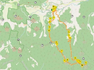
This 13–14 km circular hiking route begins in Santa Pau’s walled medieval centre and climbs the Santa Maria de Finestres ridge, reaching the mountain‑top church and the nearby castle ruins. Along the way you’ll see views of the Santa Margarida Volcano and cross landscapes shaped by ancient lava flows.
Santa Pau is a fortified hilltop village where the outer houses form the defensive walls around the central square and castle keep. The village is exceptionally well preserved, with narrow cobbled streets, stone archways, and the irregular porticoed plaça Major beside the church of Santa Maria de Santa Pau.
Wandering the lanes of Carrer de la Vila Vella and Carreró Vila Vella leads you to one of the original gates, Portal de la Vila Vella. The Mirador plaça Lluís Masó Subirats offers stepped access to the old town and a viewpoint over the Torrent de Pujolars river valley.
The southern entrance, Portal de Sant Antoni, connects plaça de Baix with the arcaded galleries of plaça Major through a Norman‑style archway. Santa Pau has a population of around 1,600 (2023). Allow about an hour to explore the village and grab breakfast before starting the hike.
Note: The Santa Pau castle is normally closed to the public but offers limited interior visits on selected dates in November 2026.
Image Gallery For Santa Pau medieval village and Garrotxa Volcanic Zone Hiking
Click on any of the 55 images to open full screen gallery player. Note that viewing images is subject to our Fair Use Policy.
Visiting Santa Pau medieval village & Garrotxa Volcanic Zone Hiking
From Plaça de Baix, follow the rural road south as it climbs gently past modern farmhouses before narrowing into a country lane that enters the forest. At the Can Pardàs farmhouse, take the right-hand fork and follow the road around the hairpin bend, then join the footpath towards Volcà Can Simó.
The trail rises across a small mountain plain where the ruined farmhouse of Can Barraca stands in one corner. Continue past the ruin and enter the forest. This section follows a ridgeline of small peaks, passing the minor summits of La Costa (639 m) and Coll de Maria (619 m). Along the way you’ll notice rocky outcrops formed from ancient lava flows — a reminder that this entire landscape was shaped by volcanic activity.
The path continues ascending through the forests of Les Marrades (800 m) before reaching a terraced mountain plain known as Collada de Grau (873 m). Cross the plain and take the Coll del Grau forest path, which climbs the Serra de Grau ridge, passing a series of small summits at 936 m, 938 m and 955 m.
At the summit of Puigsallança (1,027 m), a concrete trig pillar marks the highest point of the route. A natural rock ledge nearby offers a superb viewpoint over the forested volcanic cones of the Garrotxa region. Continue along the ridge to the Mirador del Forat de l’Ovella (846 m), a mountain pass with striking views of ribbed, folded rock formations emerging from the forest canopy.
Further along the trail you’ll see the mountain-top church of Santa Maria de Finestres (877 m). A path circles the building, allowing you to appreciate this remote religious site, first documented in 947 AD. The current structure incorporates elements from 1174, when the abbots converted it into a Benedictine priory that housed a small monastic community for four centuries. The church suffered major damage during the 1428 earthquakes, which collapsed its vault and sections of its walls.
To reach the next viewpoint, backtrack slightly and take the path to the Castell de Finestres ruins (957 m). Almost nothing remains of the castle itself, but the viewpoint is spectacular, offering a panoramic overlook of Santa Maria de Finestres and the surrounding mountains. A small mountain shrine stands nearby. This is an ideal place to stop for lunch.
To descend back to Santa Pau, return towards Forat de l’Ovella and take the G991 Fageda de Finestres trail on the right. You’ll soon reach the square stone shrine known as the Oratori de Finestres. The path then descends through forest, passing Coll de Puigsafont (802 m) and beginning to parallel the Torrent de la Salgueda river. A short distance further you’ll find the natural spring of Font de la Salgueda.
The trail eventually reaches the ruined farmhouse of La Coma (556 m), where it joins a gravel track that transitions into a paved rural road serving several holiday cottages, including Mas el Pont, Mas el Pla, Planademunt and Mas Planadevall. Do not follow the road towards these houses; instead, take the forest footpath towards Can Gordi.
After passing the Can Gordi farmhouse, the path becomes the rural road known as Camí de la Doma, which leads directly back to Santa Pau village.
Nearby Santa Pau points of interest
If you’re visiting Santa Pau on an autumn weekend, I highly recommend the beautiful and easy 10 km circular walk to the Santa Margarida Volcano. The crater is a wide grassy plain with a small stone chapel, the Ermita de Santa Margarida, standing right in the centre.
For families or visitors looking for something more relaxed, Lava Parc offers activities around the Croscat volcano, including pony rides and horse‑drawn carriage tours through the forested volcanic landscape.
Hiking from Santa Pau village to Santa Maria de Finestres with a Dog
This route is generally suitable for dogs and should not present any particular difficulties. The terrain is varied but manageable, and there are plenty of shaded forest sections.
However, be aware that the forests around Santa Pau can contain poisonous mushrooms in autumn, and during spring and summer you may encounter pine processionary caterpillars, which are dangerous to dogs due to their toxic hairs.
Note: At the end of October, rural areas around Santa Pau may host boar hunting with rifles and packs of dogs. If your hike coincides with hunting days, dress your dog in a fluorescent vest and keep it on a leash for safety. Remain on the paths outlined in this route.
Best Time to Visit Santa Pau village
Autumn and winter are the best seasons to visit Santa Pau and the Garrotxa Volcanic Zone. The forests here are dominated by beech, oak and chestnut, and their colours shift dramatically as the weather cools — deep golds, reds and copper tones in autumn, followed by clear winter light filtering through the bare branches.
Temperatures are cooler and the trails are quieter, making the long ascent to Santa Maria de Finestres far more comfortable than in the heat of summer. Mist often settles in the valleys on winter mornings, adding atmosphere to the volcanic landscape and the medieval streets of Santa Pau.
Spring is also pleasant, but autumn and winter offer the most striking forest colours and the most rewarding hiking conditions.
What to take with you for Santa Pau medieval village & Garrotxa Volcanic Zone Hike
This is a medium‑difficulty mountain route in the foothills of the Pyrenees, so a small hiking rucksack with the essentials is all you need. I always carry a basic first‑aid kit and an emergency waterproof or windproof jacket — the weather can change quickly at higher elevations.
Bring 2–3 litres of water, especially outside the winter months. Although the route passes a natural spring at Font de la Salgueda, it’s best not to rely on it as your only source.
Sturdy footwear is recommended. The trail includes forest paths, rocky ridgelines, and uneven volcanic terrain, so running shoes are not ideal. In autumn, the leaf cover can make the ground slippery, and in winter the shaded sections can hold moisture or frost.
If hiking with a dog, consider a fluorescent vest during hunting season and carry enough water for them as well — there are long stretches without access to streams.
Tickets for Hot Air Ballooning and Guided tours of Santa Pau
Just outside Santa Pau you’ll find a hot‑air balloon company offering spectacular flights over the Garrotxa Volcanic Zone. It’s one of the most impressive ways to appreciate the region’s tree‑covered craters, lava flows, and folded ridgelines from above — a completely different perspective from what you see on foot.
Santa Pau is also included on the itinerary of several small‑group car‑tour companies that combine the village with nearby towns such as Vic, Olot, or Besalú. These guided routes are a good option if you want to explore the wider region without doing a full day of hiking.
Powered by
GetYourGuide
Powered by
GetYourGuide
Santa Pau medieval village Garrotxa Volcanic Zone Hiking Summary of Prices
Train/Bus Fare
Entry Ticket
Additional Information
Train/Bus Fare
Entry Ticket
Additional Information
Adult
€ 25.00
FREE
Child
€ 25.00
FREE
Notes
Hike is free. Price based on 4 people sharing a car
Getting to Santa Pau medieval village
Address: Plaça Major, Santa Pau, Girona, 17811
- By car: From Barcelona, take the C‑17 north towards Vic and continue as it becomes the C‑37 in the direction of Olot. Once in Olot, follow the C‑152 into the town centre, then take the GI‑152 towards Santa Pau. The total journey time is around 90 minutes. Parking is available at Carrer de Pont, right on the edge of the medieval village.
- By bus: Santa Pau is not connected to a regular intercity bus line, but the company Teisa operates a weekend tourist bus from Olot. Olot itself is reachable from Girona or Barcelona via the Teisa route 16 service. If travelling by public transport, check schedules carefully — rural services in Garrotxa can be infrequent and seasonal.
Documents for Santa Pau medieval village Garrotxa Volcanic Zone Hiking
Wikiloc Trail for Garrotxa Volcanic Zone Santa Pau medieval village Hike
Please sign in with Google to view the Wikiloc Route map.
Sign in with Google