Cadí-Moixeró Waterfall Hike | Empedrats, Sant Jordi & Boixassa Loop
15 km circular hike in Cadí-Moixeró Natural Park. Swim at Els Empedrats, visit 5 waterfalls, summit Boixassa, and loop past Refugi Sant Jordi and forest trails
Views:
1.3k
About the Cadí-Moixeró Waterfall Route
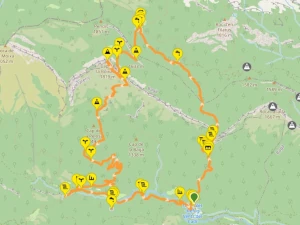
This 15 km medium-hard circular hiking route explores the lush interior of the Parc Natural del Cadí-Moixeró, following the PR-C-125 trail through forested valleys, river canyons, and panoramic mountain ridges. The route begins at Cal Cerdanyola – Aula de Natura La Salle, a nature education centre with parking and trail access.
The first section winds through beech and oak forest along the Camí dels Empedrats, passing Font Nostra and the Bullidor de la Llet — a dramatic waterfall where water bursts from the cliffside in frothy torrents, resembling boiling milk. This short diversion offers a refreshing shower but isn’t suitable for swimming.
Back on the main trail, the path enters a rocky canyon carved by the Torrent de la Font del Faig. Here you’ll find Els Empedrats, a 10 m waterfall with a natural pool and stone beach — the best swimming spot on the route. The trail continues upstream, crossing the river multiple times and passing smaller cascades and natural springs like Font Gran d’Escriu.
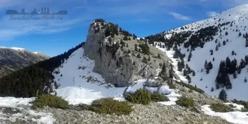
As the valley opens into Vall de Pendis, the trail climbs toward Refugi Sant Jordi (1,558 m), a mountain hostel where you may be able to grab a cold drink. From here, the route ascends through pine forest to Pas de Galigan ridge and the summit of Cap de la Boixassa (1,825 m), offering sweeping views of the Pyrenees and the Cadí range.
The descent follows a gravel track past Collada de Pelosa and the ruins of El Monnell farmhouse. As the trail transitions to a paved rural road, there are several short diversions to waterfalls: the clay-streaked Salt de Murcarols, the forest-hidden Salt Dou de Bastareny, and the bubbling Bullidor de Sant Esteve. The final stretch passes the Molí del Forat watermill ruin before returning to the trailhead.
This route is best completed in late spring or autumn when water flow is reliable. In summer, rivers may run dry, and in winter, waterfalls may freeze. With 1,087 m of elevation gain and a mix of forest, canyon, and summit terrain.
Image Gallery For Parc Natural del Cadí-Moixeró waterfalls
Visiting Parc Natural del Cadí-Moixeró waterfalls
Begin at Aparcament dels Empedrats, adjacent to Cal Cerdanyola – Aula de Natura La Salle. Follow the gravel track past Font Nostra and cross a metal-railed bridge. Turn right, stepping over a chain barrier, and continue past the stone building Refugi Vents del Cadí. The track narrows into the Camí dels Empedrats footpath, winding through forested terrain.
After a few kilometres, the trail crosses a river via a stone bridge — partially obscured by vegetation. Shortly after, take the left-hand spur to Bullidor de la Llet (1,023 m), a dramatic waterfall where water bursts from the cliffside in frothy torrents. It’s not ideal for swimming, but you can enjoy a refreshing shower before rejoining the main trail.
The path enters a rocky canyon, weaving between boulders and crossing the river multiple times. This section is visually stunning, with steep walls and fast-flowing water. You’ll arrive at Els Empedrats waterfall (1,035 m), the best swimming spot on the route — featuring a deep natural pool, stone beach, and 10 m cascade.
Continue uphill past the waterfall, noting a natural hole in the rock that offers a view down into the pool. Follow the red and yellow trail markers carefully — a cross means “not this way.” The trail passes a smaller cascade and the rocky riverbed before bearing left toward Estret d’Escriu and Font Gran d’Escriu (1,318 m), a natural spring.
Entering Vall de Pendis, the trail opens into a mountain meadow leading to Refugi Sant Jordi (1,558 m). You may be able to grab a cold drink here, but the climb isn’t over yet. Pick up the ascending forest trail that contours along the ridge to Pas de Galigan (1,688 m). A short detour along the rocky ridge reveals a stunning viewpoint.
Continue climbing to Cap de la Boixassa (1,825 m), a broad summit plateau marked by a stone cairn. Descend via the opposite side, following the GPS track carefully. At Collada de Pelosa, take the gravel track downhill, passing the ruins of El Monnell farmhouse. The trail transitions into a paved country lane — bear left here.
After ~100 m, watch for a forest path on the right leading to Salt de Murcarols, a clay-streaked waterfall with a rare joined stalactite-stalagmite column. Back on the road, continue ~500 m to reach Salt Dou de Bastareny, another dramatic cascade. A further 500 m brings you to the bubbling Bullidor de Sant Esteve.
The final kilometre follows the road back to the trailhead, passing the ruins of Molí del Forat watermill. This 15 km route involves 1,087 m of elevation gain and loss across varied terrain — forest, canyon, summit, and rural track. Allow 7–9 hours to complete the loop.
Hiking Cadí-Moixeró Waterfalls with a Dog
This route is a sensory playground for dogs. The first quarter follows a lively river with multiple swim spots and shaded forest trails. Tree cover includes beech, cork oak, and scattered pine — offering cool terrain and plenty of natural scents.
The second quarter opens into a narrow mountain plain filled with wildflowers and the occasional rabbit trail — ideal for scent-driven exploration. From Refugi Sant Jordi to the summit at Cap de la Boixassa, the trail climbs through pine forest, where there’s a seasonal risk of encountering Pine Processionary Caterpillars in spring and early summer. These caterpillars are toxic to dogs, so extra caution is advised.
The descent from the summit crosses rocky and grassy terrain before transitioning to a rural track lined with oak and beech — mostly free of pine. Once back on the paved road, there are several short diversions to waterfalls where your dog can cool off again. The route poses no technical challenges for dogs, but it’s physically demanding. Don’t be surprised if your dog opts for a rest day afterward!
What to take for Parc Natural del Cadí-Moixeró
Pack a standard mountain hiking rucksack with layers suitable for changing weather conditions. This route includes river crossings, swim spots, and exposed ridgelines, so prepare for both wet and dry terrain.
- Lightweight towel and swimwear for waterfall pools
- Escarpines (water shoes) for rocky riverbeds
- 2–3 litres of water and high-energy snacks
- Waterproof shell and sun protection (hat, sunglasses, SPF)
- Sturdy hiking boots with good grip
- Navigation tools (GPS, offline map, or Wikiloc route)
- Basic first aid kit and insect repellent
- Dog gear if hiking with a pet (collapsible bowl, leash, paw balm)
In spring and autumn, pack an extra warm layer for the summit. In summer, expect dry riverbeds and bring extra water. In winter, this route may be icy or partially snow-covered — not recommended unless properly equipped.
Parc Natural del Cadí-Moixeró waterfalls Summary of Prices
Train/Bus Fare
Entry Ticket
Additional Information
Train/Bus Fare
Entry Ticket
Additional Information
Adult
€ 25.00
€ 0.00
Child
€ 25.00
€ 0.00
Getting to Parc Natural del Cadí-Moixeró waterfalls
Address: Cal Cerdanyola, Camí de Monell a la font de l'Adou, Bagá, 08695
Take the C-16 motorway north from Barcelona toward Berga. About 18 km beyond Berga, exit at the junction signposted Bagà and follow the road into the village centre. Turn right onto Avinguda de Salarich, and at the roundabout, take Passeig de Gillebàs. Continue by turning right onto Avinguda Reina Elisenda, which skirts the town centre and transitions into Avinguda del Districte Forestal.
Follow this road past the Bagà Tourist Information Office and Camping Bastareny. Eventually, you’ll reach a Y-junction — take the ascending right-hand gravel track to reach the Aparcament dels Empedrats, located beside the Cal Cerdanyola – Aula de Natura La Salle hostel and nature centre.
There are no bars or restaurants beyond Bagà, so I recommend stopping at the Cercs petrol station on the C-16. It features a classic roadside Spanish café called Els Portals de Cercs, known for its rear terrace overlooking the Pantà de la Baells reservoir. The café has a large counter with homemade sweet and savoury pastries — some of the best you’ll find in this part of Catalonia.
Documents for Parc Natural del Cadí-Moixeró waterfalls
Wikiloc Trail for Parc Natural del Cadí-Moixeró waterfalls
Please sign in with Google to view the Wikiloc Route map.
Sign in with GoogleWeather for Parc Natural del Cadí-Moixeró Natural Park
Mountain Forecast weather for Vulturoacute; (near Cap de la Boixassa)
Where to stay near Parc Natural del Cadí-Moixeró natural Park
- Aula Natura La Salle – Cal Cerdanyola : Hostel and nature education centre located directly at the trailhead. Ideal for early starts and educational stays.
- Apartament Cadí-Moixeró : Self-catering apartment in the nearby town of Bagà. Great for families or multi-day hikers.
- Hotel Ca L'Amagat : Traditional hotel in Bagà offering comfortable rooms and local cuisine.
- Refugi Sant Jordi : Mountain hut hostel located mid-route. Ideal for breaking the hike into two days or experiencing a high-altitude overnight stay.