Cingles de Malanyeu Autumn & Winter 14 km Hike
Circular route via enchanting beach & oak forests to a ridgeline path with views of the high Pyrenees including Pedraforca plus secret waterfall desent path
Views:
1.4k
About Cingles de Malanyeu Hiking
The Cingles de Malanyeu, Catalan name Malañeu, is a striking cliff rock formation around the tiny Malanyeu hamlet in La Nou de Berguedà, comarca of Berguedà, Catalonia. Malanyeu lies at about 1,000 metres altitude on the left bank of the Malanyeu stream, a tributary of the Llobregat River. The hamlet is composed of the Sant Sadurní de Malanyeu church and a handful of farmhouses, reflecting its origins as a small rural agricultural settlement.
In the mid‑19th century, Malanyeu was described in Pascual Madoz’s Diccionario geográfico‑estadístico‑histórico as a “cuadra” (a small dependent district) of the municipality of La Nou de Berguedà, with its name recorded in both Catalan and Castilian forms. The surrounding cliffs, known as the Cingles de Malanyeu, rise as part of the western buttresses of the Serra del Catllaràs. This dramatic setting, with the hamlet nestled at the bottom of a natural bowl, has long shaped its identity as a secluded mountain community.
This Autumn and Winter 14 km circular hiking route starts in Malanyeu hamlet and ascends via beautiful beech (Las Espinedas) and oak forests to a rocky granite ridgeline route that circles the hamlet, providing views of the high Pyrenees peaks including Pedraforca, before descending via a secret waterfall laddered path back to the hamlet.
The draw of this trail is its seasonal magic. In autumn, the forest glows with golden beech leaves and bursts of red holly berries, giving the trail a festive, almost enchanted feel. In winter, the air turns crisp and still, and the views open up to reveal the white snow-capped peaks of the Pyrenees — a breathtaking contrast against the deep greens and autumn colours of the valley. There’s a quiet serenity here: the scent of damp earth, the rustle of wind through the trees, and the sense of solitude that only a remote mountain trail can offer. It’s a place to breathe deeply, slow down, and reconnect with the landscape.
Note: In one section the path is a steep but short scramble up a rock formation and near the end, the waterfall descent does involve a short ladder descent.
Image Gallery For Cingles de Malanyeu Hiking
Click on any of the 46 images to open full screen gallery player. Note that viewing images is subject to our Fair Use Policy.
Visiting Cingles de Malanyeu
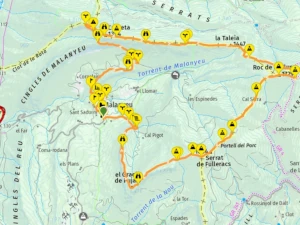
This route follows mostly the PR-C-199 hiking trail, winding through forests and along mountain-top paths.
From the parking area, follow the road towards the Sant Sadurní de Malanyeu church, passing the church and the Cal Frare farmhouse. As the rural gravel road curves to the right, look for a footpath on the left leading into the Las Espinedas beech forest. Cross the river via the wooden footbridge and bear left, following the river to the ruined water mill known as Molí de Baix. Continue upwards towards the rock formation called El Grau.
The path ascends from El Grau along a forested cliff-top trail (Cingles de Molí), arriving at a small plain with the Masia la Solaneta farmhouse. From the open plain in front of the farmhouse, there are views down to the hamlet of Malanyeu. Follow the gravel road past the farmhouse and continue towards additional farm buildings before taking a forested ascending path along a cliff formation to reach the viewpoint known as La Creueta.
Continue along the side of the cliff formation, passing Turó de la Rota, before reaching the forested area called Mal Pas. Here the path turns sharply right and climbs towards the Balma dels Desertors, a rocky forested ascent leading to the summit of La Creueta (1393 m). From here the trail levels out, following the ridgeline through the Pas de la Creueta, where several viewpoints and mini-summits (1399 m) appear between the trees.
The route continues along the ridgeline, passing small summits such as La Taleia (1445 m) and Collada de la Taleia (1428 m), before reaching Collada del Tosquer. From here, the trail turns onto the El Grapissot rock formation, heading towards the mountain plain of Collada de Sant Miquel. At the plain, take a right turn into the forested trail towards the summit viewpoint of Roc de La Clusa (1729 m).
Continue along the forested trail to reach summit viewpoints including Collet de la Font del Tudó (1645 m), Turó de Crisp (1660 m), Cap de la Baga de Cabanelles (1685 m), Portell del Porc (1639 m), Cap dels Emprius (1652 m), Serrat de Fulleracs (1644 m), Collada de la Batllia (1574 m), and along the Cingles de Rovires, enjoying the views at each summit.
At the El Grael de Pujals (1533 m) headland, the path bears right towards La Foradada (1329 m). Here you will find a rock formation with a natural window offering views over the Alt Berguedà landscape. Retrace about 50 metres from La Foradada and take the descending path on the right, following another spectacular forested cliff-top trail with panoramic views.
The path continues through the forest until reaching Griell de Cal Pigot (1139 m). The trail becomes less clear here, but it descends to the base of the waterfall. Next to the plunge pool, a path leads towards the waterfall with an opening on the left, where a metal ladder of about 3 metres allows descent to the river below as it filters through the rock. Use the handholds on the rock face and descend backwards with care.
At the bottom follow the path crossing the river and along a forested path down to a gravel road leading back to Malanyeu hamlet.
Hiking Cingles de Malanyeu with a Dog
This route passes through mixed forest of oaks, beeches, and pines, with occasional mountain plains. In spring and summer, you may encounter poisonous Pine Processionary Caterpillars. However, if you hike in autumn or winter, as recommended, these are unlikely to be present. Winter is an excellent season for your furry companion, with the forest alive with scents of wild rabbits, boar, and possibly deer.
Near the end of the route, a 3-metre metal ladder descends beside the waterfall. If your dog is too large to carry, you will need a harness to lower them safely. The ladder can be slippery, so work as a team: one person at the top, one midway, and one at the bottom to pass the dog down. For very large dogs, a diversion via the Cal Pigot farm ruins at the waterfall may be necessary.
What to take with you for Cingles de Malanyeu Hiking
This hike crosses exposed ridgelines and forested slopes in the pre‑Pyrenees, so I always pack for wind. Wear sturdy hiking boots with good grip.
Bring 2–3 litres of water, as there are no reliable refill points along the route. Snacks or a light meal are also recommended — the full loop can take 5–6 hours depending on pace and conditions.
Other useful items include a waterproof jacket, gloves, layered clothing, and a headlamp if starting late or hiking in low light.
Cingles de Malanyeu Hiking Summary of Prices
Train/Bus Fare
Entry Ticket
Additional Information
Train/Bus Fare
Entry Ticket
Additional Information
Adult
€ 25.00
FREE
Child
€ 25.00
FREE
Getting to Cingles de Malanyeu Hiking
Address: Església de Sant Sadurní de Malanyeu, Malanyeu, La Nou de Berguedá, 8698
Take the C-16 motorway north towards Berga. About 15 km beyond Berga, exit onto the local road signposted for Malanyeu. The road is winding and scenic, climbing into the foothills of the pre‑Pyrenees. I recommend parking here, just outside the hamlet.
Malanyeu has no restaurants or bars, so it’s worth stopping en route at the Cercs petrol station. Here you’ll find a classic roadside Spanish café called Els Portals de Cercs, known for its rear terrace overlooking the Pantà de la Baells reservoir. The café has a generous counter of homemade sweet and savoury pastries — some of the best you’ll find in this part of Catalonia.
Wikiloc Trail for Cingles de Malanyeu Hiking
Please sign in with Google to view the Wikiloc Route map.
Sign in with Google