Pyrenees hiking via Serra De Montgrony from Toses to Planoles
13 Km walk from Toses to Planoles via Serra de Montgrony mountain ridgeline giving spectacular 360 panoramic views descending and climbing to each peak
Views:
2.4k
About Toses to Planoles via Serra De Montgrony
Serra de Montgrony, also known as Sierra de Montgrony, is a rugged mountain ridgeline in the Parc Natural del Cadí‑Moixeró, forming the natural border between the Ripollès and Berguedà counties of the Catalan Pyrenees. Stretching from Ribes de Freser through Toses and Planoles and on to Alp and La Molina, the Serra de Montgrony covers over 35 km² of high‑mountain terrain.
This 13 km MEDIUM‑HARD hiking route begins at Renfe Toses station on the R3 Rodalies line and finishes at Planoles, one stop closer to Barcelona. Along the way you’ll pass through enchanting oak, beech and pine forests, high‑mountain plains, panoramic viewpoints overlooking the Pyrenees, and sections with clear views of the La Molina ski resort. The route also includes mountain streams, grazing pastures and several scenic ridgeline sections typical of Eastern Pyrenees hiking routes.
The trail crosses several notable summit viewpoints including Serrat de Paravent, the hammer‑stone monument at Pedra Picada, La Emperadora, Costa Pubilla, Tossal Meians and the Tossal Meians bunker. A MEDIUM level of fitness is required, and sturdy hiking boots are essential, as the descent into Planoles is steep and can be slippery in places.
The name Mogrony comes from the Latin Groyn, meaning “pig’s snout,” likely linked to the region’s traditional cuisine. The prefix Mont simply means “mountain.”
This route is ideal for hikers seeking a quiet, lesser‑known Pyrenees trail far from the crowds. It offers a genuine sense of remoteness and open‑air solitude. I have also completed this route in winter snow conditions, and during January and February the Serra de Montgrony typically receives heavy snowfall, making it an excellent candidate for snowshoe hiking or crampon‑assisted winter trekking.
Because deep snow dramatically increases effort and slows progress, attempting this as a winter snowshoe route is best done with an overnight stay in Planoles rather than trying to complete it as a one‑day trip from Barcelona. In full winter conditions, this becomes a HARD winter hike and requires proper equipment and early starts.
Image Gallery For Toses to Planoles via Serra De Montgrony
Click on any of the 68 images to open full screen gallery player. Note that viewing images is subject to our Fair Use Policy.
Visiting Toses to Planoles via Serra De Montgrony
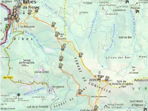
From Toses train station, follow the GIV‑4016 road over the bridge at the western end of the platform. Immediately after crossing the tracks, take a hard right onto a quiet paved lane. After around 100 metres, behind a ruined stone building, you will see a footpath climbing into the forest — this marks the start of the Serra de Montgrony ridge trail.
The initial forested section offers several viewpoints overlooking the mountain village of Toses. After crossing a small stream, take the right fork and continue ascending. Another right fork leads you through open mountain grazing land before joining a gravel track. Follow this track for 500 metres and take the right fork into the Pla de Querol mountain plain.
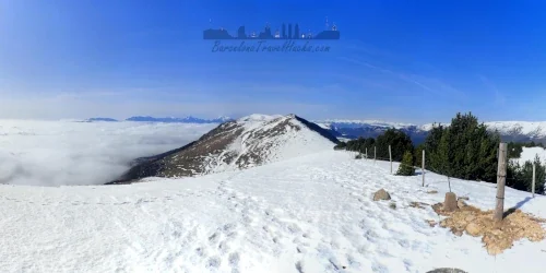
At the top corner of the plain, look for a distinctive yellow route marker made from small logs wedged into a tree branch. This marks the ascent through the Costa Borda pine forest. The trail emerges onto a wide high‑mountain plateau at Cap dels Plans del Ginebrar (1901 m), one of the key viewpoints along the Serra de Montgrony ridge. From here, the route follows a series of rolling summits with excellent views of the Pyrenees.
Turn left toward the first summit, Serrat del Paravement (1911 m), then descend to Collet de les Fontetes de Castellar (1879 m). Continue along the ridge through a small pine forest to reach the Pedra Picada summit, marked by a metal sculpture of hands striking a rock with a sledgehammer. Behind it is a semicircular stone viewpoint with excellent views toward Pedraforca.
From Pedra Picada, descend parallel to the wire fence to Coll de Remoló. Stay beside the fence and climb the rocky path to Cim de l'Emperadora (1962 m). Descend the opposite side and continue through Coll de la Bona to reach the Búnquer del Roc dels Llamps, a WWII‑era concrete bunker overlooking the valley.
Continue ascending to Tossal Meians (2051 m), then follow the ridge to the final and highest summit of the route, Costa Pubilla (Cim de Pla de Pujals) (2056 m). From here, follow the fence as it bends left and descends to Coll de Coma Ermada. Look for a gate in the fence — you must pass through it to begin the descent toward Planoles.
Cross the mountain plain and watch for a descending path on the left entering the pine forest. After exiting the forest, you will reach a muddy area around a cattle drinking tub at Fortí de la Font Negra (1786 m). Continue to Coll Roig, where a signpost points toward Campelles and Planoles. Take the path toward Planoles and follow the yellow markers carefully, as the junction can be easy to miss.
The descent continues through forested terrain, occasionally requiring you to duck under fallen trees. At Coll Garroter, enjoy a viewpoint overlooking the foothills and grazing fields. The trail eventually emerges onto a gravel road — almost immediately opposite is another descending footpath. This junction is not signposted, so pay attention to avoid missing it.
The final section descends through forest parallel to a mountain stream and joins a riverside trail beside the El Rigat river. Turn left and follow the river to a shallow ford behind the Alberg Planoles Xanascat hostel. Cross the river (either stepping on rocks or wading through 10 cm of water) and continue toward the Camp de Futbol de Planoles. Turn right onto the gravel track, then left onto the GIV‑4015 road. After 20 metres, a footpath beside the recycling bins leads up to Planoles station. Cross the tracks using the level‑crossing footpath, taking care to look both ways.
Winter Conditions on the Serra de Montgrony Route
I have completed this route in winter snow conditions, and during January and February the Serra de Montgrony typically receives heavy snowfall. This transforms the route into an excellent option for snowshoe hiking or crampon‑assisted winter trekking, especially along the wide high‑mountain plains and open ridgelines.
Deep snow significantly increases effort and slows progress, making this a HARD winter route. For safety and timing reasons, I strongly recommend an overnight stay in Planoles (or Toses) rather than attempting the full route as a one‑day trip from Barcelona during heavy‑snow periods.
With proper winter equipment and an early start, this becomes one of the most rewarding winter ridge hikes in the Eastern Pyrenees, offering spectacular views over the snow‑covered Serra de Montgrony and surrounding valleys.
Hiking the Serra de Montgrony from Toses to Planoles with a Dog
This route is generally dog‑friendly and presents no major technical difficulties for a fit and confident dog. The trail includes a mix of forested paths, open mountain plains and gentle ridgeline sections, all of which are manageable for most dogs used to regular hiking.
Take extra care when passing through the pine forest sections in spring and early summer, as the area may contain Pine Processionary Caterpillars, which are dangerous to dogs. Keep your dog close and avoid letting them sniff pine needles or low branches during this period.
The high‑mountain plains often have free‑roaming cattle, so ensure your dog remains under control and does not approach livestock. Most of the route is open terrain with good visibility, making it easy to anticipate encounters.
In winter snow conditions, dogs can still complete the route, but be aware that deep snow significantly increases effort for both humans and animals. Consider using dog booties if your dog is sensitive to ice or sharp crust snow, and plan for extra breaks and water. Winter conditions also make this a much longer day, so an overnight stay in Planoles is recommended if hiking with a dog during heavy‑snow periods.
What to take with you for Toses to Planoles via Serra De Montgrony
What to Bring in Summer
- Lightweight waterproof jacket for wind and rain in the high Pyrenees mountains
- 2–3 litres of water (no refill points along the route)
- Sun protection: hat, sunglasses and high‑factor sunscreen
- Breathable hiking clothing suitable for warm temperatures
- Sturdy hiking boots with good grip for rocky and uneven terrain
- Snacks or a packed lunch for the full‑day hike
What to Bring in Winter (snow conditions)
- Insulated waterproof jacket and warm layers for cold alpine conditions
- 2–3 litres of water (no refill points along the route)
- Crampons or microspikes for traction on snow and ice
- Thermal gloves, hat and neck warmer
- Waterproof hiking boots suitable for snow
- Headlamp in case of early winter darkness
- Snacks or a packed lunch for this demanding winter route
- Optional: hiking poles for stability on icy or uneven terrain
Toses to Planoles via Serra De Montgrony Summary of Prices
Train/Bus Fare
Entry Ticket
Additional Information
Train/Bus Fare
Entry Ticket
Additional Information
Adult
€ 21.00
FREE
Child
€ 21.00
FREE
Group/Family Ticket?
Consult Renfe Rodalies website for child fares.
Notes
Walk is free, Return train tickets costs 21.00 Euros.
Getting to Toses to Planoles via Serra De Montgrony
Address: Estacio de RENFE, Toses, 17536
Take the Renfe Rodalies R3 Barcelona–Pyrenees train (direction Puigcerdà or Latour‑de‑Carol) and get off at Toses station to start the route. The hike finishes at Planoles station, one stop closer to Barcelona on the same R3 line. This makes the route one of the best train‑accessible hikes in the Catalan Pyrenees.
The R3 Rodalies line is the only train route from Barcelona that reaches the foot of the Pyrenees, which is why many of the region’s best linear hiking routes start and end at stations along this line, including Toses, Planoles, Ribes de Freser, Queralbs and La Molina.
If you're like me and prefer to visualise the train route, check the documents section where I have a downloadable train map showing the full R3 line and all the stations used for this hiking route.
Wikiloc Trail for Toses to Planoles via Serra De Montgrony
Please sign in with Google to view the Wikiloc Route map.
Sign in with Google