Tagamanent Castle Ruin from Figaró via Vallcàrquera River
14km linear route from Figaro to Sant Martí De Centelles via Vallcàrquera river valley to Bellver Farmhouse Restaurant and Tagamanent Castle ruin
Updated: Nov 19, 2024by: Barcelona Travel HacksViews: 1.9k
About Tagamanent castle ruin from Figaró
As part of the El Montseny Natural Park, the peak of Tagamanent, Turó del tagamanent is a location for the first prehistoric settlers, with a mediaeval church ruin Santa Maria del Tagamanent, large farmhouses and old tracks travelled for hundreds of years linking flour mills and ice wells. Tagamanent is on a plateau called El Pla de la Calma, the plain of calm, and is surrounded by mountain crop fields to make a small scattered town.
Tagamanent is high above the Congost Valley on the western slopes of Montseny one hour by car or train from Barcelona. The Tagamanent summit can be reached by hiking for about three hours from Figaró or Hiking to Tagamanent from Sant Martí de Centelles.
The route starts at Figaró Renfe train Station and crosses over the River Congost via a high bridge with views of the village of Figaró. Follow the main road north throug the village taking an ascending path called Ruta dels Arbres de Vallcàrquera along Vallcàrquera river and waterfall.
The forestal river and waterfall path emerges onto a rural road to the hamlet of Vallcàrquera where you will see several beautiful stone farmhouses and Sant Pere de Vallcàrquera church.At the end of Vallcàrquera hamlet passing Can Puig farmhouse the route deviates to the left up a steap gravel path onto a rural mountain trail.
Follow this gravel trail until almost reaching Can Bosc farmhouse. The route takes a forestall path along the Serra de les Sapines to arrive at the Bellver farmhouse restaurant. A meal here costs about 35 Euros per person and is food cooked with local produce from the surrounding farms.
After Bellver restaurant the trail leads up to Taganament castle summit. From the castle follow the GR5 path down to Sant Martí De Centelles passing via the ruined Can Amet Farmhouse.
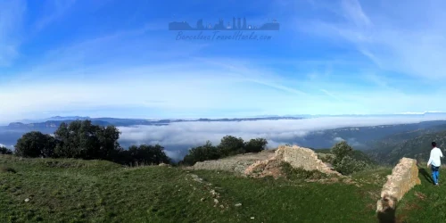
From Santa Maria del Tagamanent church there are spectacular views of the Vallés region, The plains of Osona and the Congost Valley with cliff formations. On a clear day it is possible to see Montserrat mountain and the Pyrenees which are very visible in the winter when the Pyrenees mountains are covered in snow.
Santa Maria del Tagamanent Church History
Earliest historical records mention Santa Maria del Tagamanent in 993 AD. In 1098 Viscount Folc de Cardona gave the church to Santa Fe de Conques to found a priory at the location. When this was not achieved the church passed to Sant Pere de Casserres, who governed it until 1331.
Being a parish church it was passed to Sant Martí. From the 14th Century Santa Maria del Tagamanent is always recorded as belonging to the bishopric of Vic. It had Santa Eugènia del Congost as its suffragan until 1878.
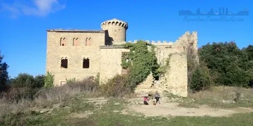
Santa Maria del Tagamanent today has been abandoned and ruined for centuries and is currently being preserved by the Diputació de Barcelona to prevent further degradation of the site. The church has a Romanesque appearance with small flourishes of gothic architecture. It sits at the summit of Turó del Tagamanent in a small grassy meadow at the top of a naturally occurring craggy escarpment. The location made it ideal for a fortified church castle.
Image Gallery for Tagamanent castle ruin from Figaró
Click on any of the 51 images to open full screen gallery player
❮❯
Visiting Tagamanent castle ruin from Figaró
I recommend allowing 6-8 hours to complete the route.
I advise at least 2 litres of drinking water.
Hiking to Tagamanent with a Dog
This is a predominantly forested hike in oaks, beeches and some pines that are in Parc Natural de Montseny. If you see Pines in the spring or summer then there may be poisonous Pine Processionary Caterpillars. The route is viable for a dog with no difficulties for your fury friend. Note that at the Church ruin and Bellver farmhouse restaurant there are free roaming semi wild cats and grazing cattle. If you are planning to eat at the restaurant, ask for an outside table on the patio or if you can eat inside with a dog. your dog will love the river and small waterfall at the start of the route.
Where to Eat in Figaró, Turó del tagamanent & Sant Martí De Centelle
Bar El Nou Cau: Caraterra de Ribes 52, 08590 Figaró
Bar Pep: Caraterra de Ribes 64, 08590 Figaró
Pa i Pastissos Can Girabent (Bakery): Caraterra de Ribes 68, 08590 Figaró
Restaurant El Bellver: Masía El Bellver, 08593 Tagamanent - Open for Lunch on weekends and public holidays. This rural restaurant serves a lunch (13:00h to 15:30h) of local seasonal organic dishes. Lunch costs about 35 € per person and has to be booked in advance.
Cafe Habana: Plaça l'Abella 8, 08592 Sant Martí De Centelles
Bar del Poble: Carrer Estació, 08592 Sant Martí De Centelles
What to take with you for Tagamanent castle ruin from Figaró
This is a medium walking route in the Montseny mountains. I always do it with a small rucksack of the essentials and first aid kit. Emergency waterproof jacket is optional depending on the weather forecast.
Take 2 to 3 litre of water. Additional water can be purchased at the El Bellit farmhouse if it is open.
Tagamanent castle ruin from Figaró Summary of Prices
Click on any one of the 2 PDFs to view in full screen and download.
Wikiloc Trail for Tagamanent castle ruin from Figaró
a0234 - Tagamanent castle ruin from Figaro
Linear route from Figar? to Sant Mart? de Centelles going up Valcarquera river valley to Bellver Farmhouse Restaurant and Tagamanent Castle ruin via forestal paths.