Warning: Undefined array key "HTTP_ACCEPT_LANGUAGE" in /home/barcjkkl/public_html/App/Config/MySQL/language.php on line 32
Deprecated: explode(): Passing null to parameter #2 ($string) of type string is deprecated in /home/barcjkkl/public_html/App/Config/MySQL/language.php on line 36
La Garriga to Figaró via Cingles de Bertí & Clascar Castle
A 17km route via Puiggraciós Church and semaphore, Clascar castle ruin, along the top of a cliff wall. Spectacular valley views, returning via a waterfall
Updated: Nov 18, 2024by: Barcelona Travel HacksViews: 2.9k
About La Garriga Los Cingles de Bertí Figaro
A linear walking route of 17km starting at La Garriga Renfe station and ending at Figarò Renfe Station via Puiggraciós Church and Puiggraciós semaphore, Cingles de Bertí cliff and Clascar ruined castle.
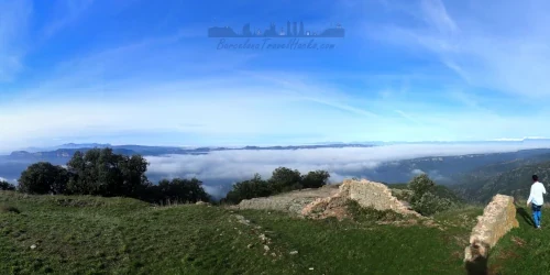
This is a beutiful hiking route about one hour from Barcelona by train that provides spectacular views of the Congost river valley, Turó del tagamanent, Montseny Massive and on a clear day, the Pyrenees.
Leaving La Garriga via Avenida de Sant Esteve, the first point of interest is the Sant Esteve de la Doma church and cemetery. From here the route take a rural road gravel path up through vineyards, olive groves and oak forests arriving at Puiggraciós Church and Sanctuary. Behind the church is a picnic area. as well as the views from the church, the Puiggraciós semaphore watch tower gives views of the Cingles de Bertí and Congost river valley.
From Puiggraciós semaphore watch tower the route passes via a winding rural road that runs next to a section of the Cingles de Bertí. You can clearly see the rock stratification of different millennia. Look out for the various seams full of tiny shells. The path takes you to El Clascar which is an abandoned stately home in the style of a castle. Another great spot for a break or picnic.
After Clascar, the route follows along the top of the ridge of the Cingles de Bertí and there are several points along this section of the path with great views into the Congost Valley and beyond. At El Rajadell rural farmhouse the path deviates to the right and takes a descending zig zag route down the Cingles de Bertí rock formation to an area known as La Trona, a huge rock that juts out from the cliff and popular destination for climbers.
The trail from La Trona to Figarò follows a path along a gorge filled with huge limestone columns and waterfalls passing via a cave. Cross the railway line with care looking both ways. Once in Figarò village the railway station is nearby.
This trail follows mostly rural roads and often traversed paths that are marked with Yellow then later red route markers on the rocks and tree's.
Image Gallery for Image Gallery For La Garriga Los Cingles de Bertí Figaro
Click on any of the 83 images to open full screen gallery player
❮❯
Visiting La Garriga Los Cingles de Bertí Figaro
Allow 6-8 hours to complete the route.
I recommend 2 to 3 litres of water because there is nowhere to top up along the route.
Hiking the Cingles de Bertí with a Dog
Most of this route is forestall and mountain plains. You may come across poisonous Pine Processionary Caterpillars in spring and summer. If you do this route in Autumn or winter, as I recommend, there is a low probability of finding Pine Processionary Caterpillars. The forests around the river and waterfall will also contain scents of wild rabbits, boars and possibly deer which your fury friend will love. take care along the section of path next to the cliff.
Where to Eat in La Garriga
Note: In Figarò there are no bars or restaurants open in the afternoon on the weekends so take plenty of food and water, or time depending, stop off for wine and tapas in La Garriga on the way home.
La Garriga has plenty of Bars and restaurants. My recommendations are below.
D'arbois: Plaça de l'Església 4, 08530 La Garriga
Taj Mahal: Plaça de l'Església 5, 08530 La Garriga
Forn del Bac (Bakery): Carrer del Centre 41, 08530 La Garriga
The route starts from La Garriga Renfe on the R3 RODALIES train line and terminates in Figarò Renfe train station on the same R3 Line. This trail is less than one hour from Barcelona by train.
2 Documents for La Garriga Los Cingles de Bertí Figaro
Wikiloc Trail for Wikiloc Trail for La Garriga Los Cingles de Bertí Figaro
a0235 - La Garriga to Figaró via Cingles de Bertí
Spectacular views of the Congost river valley via rural church and telegraph watchtower, A ruined castle, views of los Cingles de Bertí cliff face, a waterfall and small cave.