Warning: Undefined array key "HTTP_ACCEPT_LANGUAGE" in /home/barcjkkl/public_html/App/Config/MySQL/language.php on line 32
Deprecated: explode(): Passing null to parameter #2 ($string) of type string is deprecated in /home/barcjkkl/public_html/App/Config/MySQL/language.php on line 36
Mola De Colldejou Plateau Hiking Trail in Llaberia Natural Park
18km route in Llaberia natural park via forestall paths. Ravine to Moll de Colldejou plateau ruined castle. Panoramic views of coastline and interior landscape
Updated: Nov 19, 2024by: Barcelona Travel HacksViews: 2.6k
About Mola de Colldejou Plateau
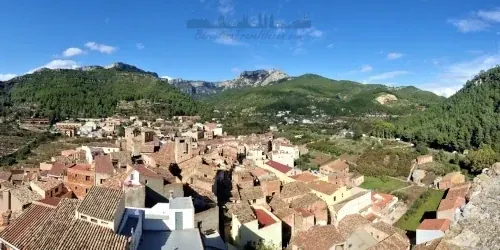
Mola de Colldejou is a mountain plateau in the Llaberia natural park. There are multiple routes in this park and this circular route starts and ends at the Marçá-Falset Renfe station, 2 hours from Barcelona. The walking route is 18km long and mostly comprises walking on rural roads and forestall tracks. There is a section of steep uphill that traverses a rocky ravine to reach the top of the plateau. People who suffer from vertigo may have issues with this section of the route.
Once on the top of the Mola de Colldejou plateau there are spectacular views of the Llaberia natural park and surrounding ridges of wind turbines. In the corner of the plateau is the ruined Mola de Colldejou castle, probably part of the visual semaphore network that was used to communicate pre-invention of the telegraph/telephone.
Descend by traversing a cliff top path along the plateau and down through a pine forest path to a rural track leading back to the train station.
Image Gallery for Image Gallery For Mola de Colldejou Plateau
Click on any of the 86 images to open full screen gallery player
❮❯
Visiting Mola de Colldejou Plateau
Allow 7-9 hours to complete the route.
A MEDIUM level of fitness is required. It took me 7 hours to complete but I did stop a lot to take photos! Also sturdy and grippy hiking boots are also required on the ravine section of the trail.
NOTE: Before planning to do this route check the weather for the town of Reus or Tarragona to verify that there is no rain or high winds forecast. The first time when I completed this route was with winds gusting up to 100km/h on the plateau and it was a little dangerous along the cliff top path and ravine ascent.
Mola De Colldejou Plateau Hiking Trail with a Dog
This is a predominantly forested hike in oaks, beeches and some pines that are in Llaberia Natural Park with a section of shrub and grass land at the top. The descent is via a section of path through a pine forest so there may be poisonous Pine Processionary Caterpillars in spring and summer. However, I recommend this as a winter hike so there is a low probability of coming across Pine Processionary Caterpillars but be vigilant. The route is fine for a dog except for the ravine section where you may need to give your dog a leg up to get up some of the larger boulders. Note that there are free grazing goats and cattle at the top plateau as well as a cliff top path.
Where to eat and drink
Restaurant Les Agulles: inside Marça-FalsetGreat station building
Estación de Tren Marçá-Falset, 43775 Marçá, Tarragona
Opens from 9 till 20h
What to take with you for What to take with you for Mola de Colldejou Plateau
I pack for wind when doing this hike because it is along a ridge line.
I recommend 3 to 4 litres of water because there is nowhere to top up along the route.
Mola de Colldejou Plateau Summary of Prices Summary of Prices
For this route to be viable as a day trip you must get either the 06:33 train or the 09:03 train from Barcelona-Sants. If you are not a frequent mountain walker or in good physical shape then I suggest the 06:33 train to have plenty of spare time.