Warning: Undefined array key "HTTP_ACCEPT_LANGUAGE" in /home/barcjkkl/public_html/App/Config/MySQL/language.php on line 32
Deprecated: explode(): Passing null to parameter #2 ($string) of type string is deprecated in /home/barcjkkl/public_html/App/Config/MySQL/language.php on line 36
Montsant Escaladei & Clot del Cirer 15Km circular route
Spectacular mountain route from former grand monastery via Montsant cliffs & mountain plateau to Clot del Cirer natural spring & Roca de miso viewpoint
Updated: Nov 22, 2024by: Barcelona Travel HacksViews: 1.9k
About Montsant Escaladei & Clot del Cirer
The Montsant mountain range is about 20Km inland behind Tarragona city and is part of the Catalan Pre-Coastal Range. The main peaks are Roca Corbatera (1163 m), Pilo dels Senyalets (1109 m) and La Cogulla (1063 m). The Serra de Montsant, meaning Holy Mountain Range is named because there were many hermits living in the mountains in early Medieval times. Today Montsant mountains are a protected natural park.
This circular 15km route starts and ends at the Cartoixa d'Escaladei monastery museum located at the foot of the Montsant sierra.
Cartoixa d'Escaladei Monastery Museum
The Carthusian monks followed a model of life marked by silence and prayer, combining hermitistic loneliness with the auspices of community life. The monastery was founded in 1194 with a concession from King Alfonso I, for the purpose of forming a settlement on newly conquered lands. The donations and purchases that took place later turned the monastery into a feudal lord responsible for the county today known as Priorat and famous for grape growing and wine production.
Escaladei was a very wealthy and powerful monastery earning money from land rental of the very profitable grape fields and was known for its splendour between the 16th and 17th centuries. This wealth was used by the Carticans monks to undertake a profound architectural remodelling. From the first half of the 19th century onward, the confiscation of land owned by the Church and the looting produced during the popular uprisings caused the monastery to be abandoned.
Today, The monastery is being preserved with some sections undergoing extensive restoration works. The monastery is a museum that can be visited at the start of this hiking route. I would allow 30 to 60 minutes to explore the inside of the monastery.
The route starts from the Monastery museum and heads up into the mountains via abandoned monastic ruins of La Pietat and grape fields. At the foot of the cliffs the path is traversed in several sections by steep ravines with chains to aid the climb. The top of the mountain is a plateau with several summits such as Punta Alta del Boter (1007 m), La Guardiola (1014 m) and La Cogulla (1062 m). Between La Guardiola and La Cogulla is a large natural cave often used by mountain goats to take shelter from the wind and rain.
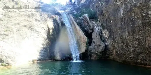
Further along the route we take a path going down into a natural basin with a spring called Clot de Cirer. From here we go back up to the plateau and follow a cliff top path at Roca de Miso that gives spectacular views of the Montsant cliffs and grape fields down below. From here the path descends down the side of the cliffs into a forest that emerges into the grape fields leading back to the monastery.
Image Gallery for Image Gallery For Montsant Escaladei & Clot del Cirer
Click on any of the 73 images to open full screen gallery player
❮❯
Visiting Montsant Escaladei & Clot del Cirer
The route does involve some steep sections up some short ravines that have chains to traverse ascents of up to 2 metres so is not a route for anyone that has difficulty with hands and feet ascents or suffers from mild vertigo. It is possible to do it with dogs but you may need 4m of rope and a dog harness or at least three people to manhandle the dog up the chains section. If your dog is the size of a pony then it is probably not viable!
The best time of year to visit is during the harvest at the beginning of September or any time over winter due to the coastal location never receiving heavy snow fall like the Pyrenees.
Allow 6-8 hours to complete this route. A MEDIUM level of fitness is required.
For a complete weekend this hiking trip can be combined with a second day of hiking in Siurana. Staying overnight in Siurana.
Hiking Montsant Escaladei & Clot del Cirer with a Dog
This is a predominantly forested hike in oaks, beeches and some pines that are in Montsant Natural Park with a section of shrubland at the top. If you see Pines in the spring or summer then there may be poisonous Pine Processionary Caterpillars. However, I recommend this as a Autumn hike so there is a low probability of coming across Pine Processionary Caterpillars.
Note: it is viable to do this route with a dog and I have hiked it with a small dog. As you can see from the photos there is a section that involves scrambling up large boulders using a chain to assist so you will have to help your dog up here. Further up there is a narrow ravine pass and another scramble up a 30 degree rock incline using chains. The dog was able to complete this section without assistance. I recommend a dog harness and 4m of rope if you dog is large and you are not able to carry it or lift it it between two people.
Cartoixa d'Escaladei Monastery Museum Opening Hours & Tickets
16th December to 28th February: 10:00h to 16:00h
1st March to 31st May: 10:00h to 17:30h
Easter weekend Friday, Saturday and Sunday: 10:00h to 19:00h. Monday 10:00 to 17:30
1st June to 30th September: 10:00h to 20:00h
1st October to 15th December: 10:00h to 17:30h
Closed: Non festive Monday's, 25th,26th December and 6th January.
Ticket office closes 30 minutes before closing time.
€5 for adults over 16 and under 65 years of age.
€3 for pensioners over 65 years, Students and holders of Carnet Jove or groups of 10 or more people.
Free for under 16 years of age, Disabled visitors, tour guides, Members of Associació de Museòlegs de Catalunya or International Council of Museums or International Council of Monuments.
Free entry the last Tuesday of every month from 1st October till 30th June.
Poboleda Grape Harvest Festival
The first Saturday of September, 2nd September 2023, Poboleda celebrates a festival based on old fashioned harvesting techniques. Visitors can take part in the harvest early in the morning by accompanying villagers to the vineyards, followed by a popular open-air breakfast in the village. The grapes harvested are then crushed in the old way and the fair continues with wineries offering wine tastings.
What to take with you for What to take with you for Montsant Escaladei & Clot del Cirer
I pack for wind when doing this hike because it is along a ridge line.
I recommend 3 to 4 litres of water because this is a dry mountain range.
Montsant Escaladei & Clot del Cirer Summary of Prices Summary of Prices
Train/Bus FareEntry TicketAdditional InformationTrain/Bus FareEntry TicketAdditional InformationAdult€ 20.00FREEChild€ 20.00FREEGroup/Family Ticket?Cartoixa d'Escaladei monastery museum 10+ people 3 Euros entryNotesWalk is free, Cartoixa d'Escaladei monastery museum 5 euros entry
Getting to Montsant Escaladei & Clot del Cirer
Address: Rambla de la Cartoixa S/N, Escaladei, 43379
This area is not served by train or bus and is uniquely accessible by car, being 1h50m drive from Barcelona.
Park OUTSIDE of the monastery parking area gates so that when you return from the hike and find the monastery is closed your car is not locked inside.
3 Documents for Montsant Escaladei & Clot del Cirer
Wikiloc Trail for Wikiloc Trail for Montsant Escaladei & Clot del Cirer
a0270 - Montsant Escaladei and Clot del Cirer
Spectacular mountain route from former grand monastery via Montsant cliffs & mountain plateau via Clot del Cirer natural spring & Roca de miso viewpoint