Aigüestortes Vall de Peguera – Estany Negre & JM Blanc Refugi
A challenging 15 km hike from Espot through Vall de Peguera to Estany Negre and Refugi Josep Maria Blanc, passing waterfalls, forests and high‑mountain reservoirs
Views:
1.5k
About Aigüestortes Vall de Peguera Black Lake & Reservoirs
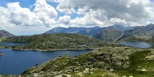
Vall de Peguera, deep within the Parc Nacional d’Aigüestortes i Estany de Sant Maurici, is one of those rare corners of the Pyrenees where the landscape feels untouched, powerful and almost secret. The moment you step into this valley, the world narrows to the sound of water, the scent of pine and the steady rhythm of your own footsteps. It’s a place where the mountains rise sharply around you, where glacial lakes like Estany Negre de Peguera and Estany de Tort de Peguera sit like mirrors between granite walls, and where the silence is so complete it feels like part of the scenery.
Starting from the village of Espot, this journey into the Vall de Peguera is more than a hike — it’s an immersion into one of the most dramatic high‑mountain landscapes in Catalonia. The valley leads you upward through forests, waterfalls, rivers and open alpine plains, eventually revealing the iconic Refugi Josep Maria Blanc perched beside its turquoise lake. Every step brings a new shift in colour, light and altitude, and the higher you climb, the more the valley opens into a world shaped by glaciers and time.
This is a route for hikers who crave solitude, big scenery and the feeling of earning every viewpoint. Whether you come in the warmth of August or in early spring when snow still lingers on the upper slopes, Aigüestortes Vall de Peguera rewards you with landscapes that stay with you long after you’ve returned to Espot. It’s challenging, unforgettable and easily one of the most inspiring hikes in the entire Aigüestortes Natural Park.
Carros de Foc
Carros de Foc is the legendary multi‑day traverse of the Parc Nacional d’Aigüestortes i Estany de Sant Maurici — a 60‑kilometre high‑mountain circuit linking the park’s most iconic refugis, from Refugi d’Amitges to JM Blanc, Colomina, Saboredo and beyond. For many hikers, it’s the ultimate Pyrenean challenge: a week spent crossing glacial basins, climbing between granite peaks and waking up each morning in a different corner of the national park.
The route has a certain mythology to it. It feels wild, remote and beautifully old‑fashioned — a journey that rewards endurance, curiosity and a love of big landscapes. Starting and ending in Espot, Carros de Foc takes you through some of the most dramatic terrain in Aigüestortes, including the rugged passes above Estany de JM Blanc.
On this page, I present the last section of the Carros de Foc as a one‑day hike to Estany negre, and Refugi JM Blanc, returning to Espot the same day. It’s a perfect way to experience a taste of the route without committing to the full multi‑day itinerary. The only reason I haven’t done the complete Carros de Foc myself is simple: I love mountain hiking, but I am also a pampered poodle that love's a warm bed, a good shower and a proper dinner at the end of the day.
You’ll also find other sections of the Carros de Foc woven into my one‑day routes, including Aigüestortes – Espot to Sant Maurici & Ratera Waterfall and Aigüestortes – Vall de Fosca. Each of these hikes gives you a glimpse of the larger circuit — a way to experience the spirit of Carros de Foc one beautiful day at a time.
Image Gallery For Aigüestortes Vall de Peguera Hike
Click on any of the 80 images to open full screen gallery player. Note that viewing images is subject to our Fair Use Policy.
Visiting Aigüestortes Vall de Peguera Black Lake & Reservoirs
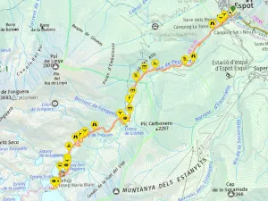
The trailhead begins at the edge of Espot village. From the parking area at the entrance to the village on the LV‑5004 road, walk through Espot via Calle de Peguera, passing the traditional stone houses as you climb toward the start of the Camí de Peguera. Once you leave the road and join the gravel track, you’ll pass Camping La Torre on the right.
This well‑marked trail forms part of the GR 11 long‑distance route leading to Estany Negre de Peguera and Refugi Josep Maria Blanc. Early on, you’ll see a waterfall on the right before the gravel transitions into a footpath. The trail settles into a steady uphill climb through shrub and shady woodland as it enters the Vall de Peguera. The path parallels the Riu Peguera, crossing it several times via wooden footbridges that offer excellent views of the river tumbling over its rocky bed. Keep an eye out for a large waterfall on the left.
After roughly three kilometres, the forest opens into small mountain plains with swampy ground crossed by wooden planks. The path passes a stone farmhouse ruin before re‑entering the forest and continuing another one and a half kilometres to Estany de Lladres, a dammed lake with a small hydroelectric plant called Presa de la Font Grassa. This is usually where I stop for a short break and a snack.
From here, the trail follows a gravel road where the tree canopy becomes thinner. After another kilometre, you’ll pass Estany de Trescuro in the distance before the path climbs steeply along a zigzagging route for one and a half kilometres. As the trail levels out, the corner wall of the Estany Tort de Peguera reservoir comes into view. Most hikers continue along the gravel road, but I prefer walking across the top of the dam and following the small lakeside path that leads directly to Refugi JM Blanc. In summer, when the refugi is open, you can enjoy a beer, wine or something stronger while sitting at the lake’s edge, taking in the panoramic lake view.
Note: Swimming is not permitted in any of the lakes in Aigüestortes Natural Park. Rangers do issue fines, so I cannot recommend swimming in front of the refugi.
From Refugi Josep Maria Blanc, follow the gravel road for 350 metres to reach Estany Negre de Peguera. Despite its name, the lake is not dark at all — its water is a perfect, crystal‑clear blue. From the small dam wall, the path zigzags up the mountain to the right before dropping down to a quiet spot beside the water. This is one of my favourite places to rest, surrounded by granite mountain walls and conifers reflected in the glacial lake.
Estany Negre de Peguera is the turnaround point of this route. Return to Espot via the same path used for the ascent. The Aigüestortes Vall de Peguera hike is a challenging 15 km circular route that I have completed twice — once in August and once in early spring when snow still lingered on the upper section.
Allow seven to nine hours to complete this route.
Aim to start around 10:00 am to comfortably reach Estany Negre.
This hike can also be done as a two‑day Aigüestortes adventure by staying overnight at Josep Maria Blancis gives you time to explore beyond Estany Negre and enjoy even more breathtaking views.
I often do this as a one‑day hike as part of a weekend getaway — day one in Vall de Peguera, and day two hiking to Maurici Lake and Ratera Waterfall.
Hiking Aigüestortes Vall de Peguera Black Lake & Reservoirs with a Dog
This route is excellent for dogs, and I’ve completed it twice with a furry hiking companion. The climb to Refugi JM Blanc is steady and continuous, so it’s physically demanding for both humans and dogs, but any fit and active dog will enjoy the challenge. The terrain is varied, with streams, forest shade and plenty of natural places to stop for water and rest.
Snow can linger on the upper section of the trail until the beginning of May, especially around the refugi and Estany Negre de Peguera. If you’re hiking early in the season, keep an eye on your dog’s paws and make sure they stay warm and comfortable. For most of the year, though, this is a classic high‑mountain hike where dogs can happily roam in shorts‑and‑T‑shirt weather alongside you.
The foliage is mostly scrub and open woodland with a short section through pines. Encounters with Pine Processionary Caterpillars are unlikely at this altitude, but it’s still wise to stay alert during spring and summer.
I’ve rated this route five stars for dog fun on my Hiking with a Dog page — it’s one of the most rewarding dog‑friendly adventures in the Aigüestortes Natural Park.
Where to Eat in Espot
- Restaurant La Llúpia: Plaça Doctor Benavent 5, 25597 Espot
- Pizzeria Al Dente: Carrer Clopeta 4, 25597 Espot
- Restaurant Juquim: Plaça Sant Martí 2, 25597 Espot
What to take with you for Aigüestortes Vall de Peguera Black Lake
This is a medium‑hard mountain route, and having the right basics makes the day far more comfortable. For most of the hiking season you’ll be perfectly fine in shorts and a T‑shirt, as the climb through the Vall de Peguera is warm, sunny and sheltered in many sections. I usually carry a small rucksack with the essentials and a compact first‑aid kit.
A lightweight windproof or waterproof jacket is worth packing. You may not need it, but the higher sections around Refugi Josep Maria Blanc can get breezy, and weather in Aigüestortes can shift quickly. Good trail shoes are important — the terrain mixes forest paths, rocky sections, dam walls and zigzag climbs.
Start the route with two to three litres of water. There is plenty of fresh water in the lakes and streams, but it’s best to begin the day well‑hydrated. Sun protection is essential at this altitude: bring a hat, sunglasses and sunscreen, especially in summer when the granite reflects the light.
If you’re hiking in early spring, be aware that snow can linger on the upper part of the trail until early May. In these cases, pack an extra layer and check conditions before setting out. For the rest of the season, this is a classic warm‑weather Pyrenees hike where simple, comfortable gear is all you need.
Aigüestortes Vall de Peguera Black Lake & Reservoirs Summary of Prices
Train/Bus Fare
Entry Ticket
Additional Information
Train/Bus Fare
Entry Ticket
Additional Information
Adult
€ 25.00
€ 0.00
Child
€ 25.00
€ 0.00
Getting to Aigüestortes Vall de Peguera & Espot
Address: Espot, Lleida, 25597
- By Car: The easiest and most reliable way to reach the trailhead. Parking is available at the entrance to the village of Espot, just off the LV‑5004 road. From here, it’s a short walk through the village to the start of the route.
- By Public Transport (Winter Ski Season Only): Public transport to Espot operates exclusively during the winter ski season. If you book in advance, there is a bus service that connects to the Port Ainé and Espot Esquí resorts, stopping in Espot village. There is no public transport option to reach Espot during the summer hiking season.
- Renfe Train from Barcelona to Lleida: AVE high‑speed service (1 hr 10 min) from €25.00, or Regional Express (2 hr 30 min) from €19.00.
- FGC Train from Lleida‑Pirineus to Pobla de Segur: Approximately 1 hr 10 min, from €7.15.
- Alsa Bus: From Pobla de Segur to Espot, or a direct Alsa bus from Lleida during the ski season.
Documents for Aigüestortes Vall de Peguera Black Lake & Reservoir
Wikiloc Trail for Aigüestortes Vall de Peguera Black Lake Hike
Please sign in with Google to view the Wikiloc Route map.
Sign in with GoogleWeather for Aigüestortes Vall de Peguera & Espots
Mountain Forecast weather for Aigüestortes Pic Morto
Where to stay near Aigüestortes Vall de Peguera in Espot
- Le Petit Espot — I stayed in this apartment when I did this hike along with the Ratera Waterfall route. It has everything you need for a comfortable weekend: a fully equipped kitchen, washing machine, Wi‑Fi, comfortable beds and a modern bathroom.
- Hostel Casa Palmera — A good low‑cost option with Wi‑Fi and ensuite bathrooms. Ideal if you want something simple, clean and close to the trailhead.
- Roca Blanca — A traditional hotel offering a gym, sauna and Wi‑Fi. A solid choice if you prefer hotel comfort after a long day in the mountains.
Nearby Attractions to Aigüestortes Vall de Peguera Black Lake & Reservoirs Hike
 CAR
CAR
1.6k views
Aigüestortes Vall de Fosca – Mountain Lakes & Cable Car Hiking Route
Demanding 14 km circular hike in Aigüestortes Vall de Fosca, linking seven glacial lakes via the cable car to Estany Gento, historic dams and dramatic Pyrenees scenery
Read more >
 CAR
CAR
1.4k views