Camino de la Ronda – Day 3 of 3 on the Costa Brava
A 14 km GR‑92 hike from Aiguablava or Fornells to Begur, passing Sa Tuna, Aiguafreda and coastal cliffs before finishing at the hilltop Begur Castle
Views:
2.8k
About Camí de la Ronda DAY 3 in Costa Brava
Day Three completes this three‑day walking (and swimming) journey along what I believe is the most beautiful stretch of the GR‑92 Camí de la Ronda on the Costa Brava. Over the past two days, the route has linked a chain of coves, pine forests and whitewashed fishing villages — S’Alguer, Calella de Palafrugell, Llafranc, Tamariu, Aiguablava, Fornells, Sa Tuna and Aiguafreda — before turning inland toward the hilltop town of Begur.
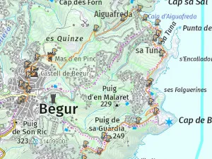
This final stage covers the 14 km between Aiguablava or Fornells and Begur, ending at the castle viewpoint above the town. It’s a varied day: rocky headlands, tunnels beneath private houses, rugged cliff paths, and two of the most beautiful coves on the Costa Brava — Sa Tuna and Aiguafreda.
Camí de la Ronda Vocabulary
When talking about place names, I use local Catalan vocabulary:
- Cala – Cove
- Camí – Path
- Cap – Headland
- Castell – Castle
- Platja – Beach
- Far – Lighthouse
- Poblat Ibèric – Iberian settlement ruins
- Torre – Watchtower
- Mirador: viewpoint
Image Gallery For Camí de la Ronda DAY 3 in Costa Brava
Click on any of the 83 images to open full screen gallery player. Note that viewing images is subject to our Fair Use Policy.
Visiting Camí de la Ronda DAY 3 in Costa Brava
The route leaves Platja d’Aiguablava via a stepped path carved into the rocks on the left side of the beach. This leads to a fenced walkway around the headland and into Port d’Esclanyà. Although it appears to be a dead‑end, the GR‑92 continues through a tunnel at the back of the beach. The tunnel emerges onto a small road that loops back to the coastline, passing Cala Malaret and weaving between the houses and rocky inlets of Fornells, including Platja de Fornells and Port de Fornells.
The trail dips into another tunnel beneath a private property before heading inland and climbing through coastal pine forest. Once on top of the headland, the route follows a gravel path with views toward Far de Begur. It then enters a small housing urbanisation before reaching a rugged cliff‑top section that leads to a stone summit marker overlooking the spectacular Cala Sa Tuna.
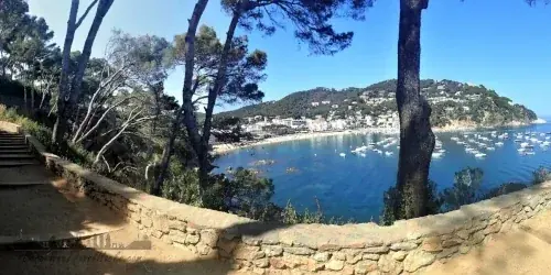
The descent into Sa Tuna is a winding cliff path with constant sea views. This is one of the most picturesque fishing villages on the Costa Brava — a sheltered cove framed by white houses and a watchtower. I recommend swimming at Platja de Sa Tuna; the water is clear and calm, and the setting is unforgettable. Restaurant Es Furió serves excellent patatas bravas. Leaving Sa Tuna is genuinely difficult because of how beautiful it is, but the GR‑92 continues from the north side of the beach.
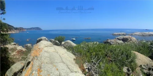
The next section is a paved coastal path along scenic rock bluffs leading to Cala Aiguafreda, a rocky cove where small boats are launched. There’s a small beach bar behind the cove. From Aiguafreda, the route heads inland, climbing through forest toward Torre del Mas d’en Pinc, a fortified Catalan farmhouse with a tower that now serves as a small museum. Beyond this point, the trail enters the outskirts of Begur.
Begur sits 2 km inland at around 200 m above sea level. The town has a long history, reflected in the Begur Castle ruins dating from the 16th and 17th centuries. The castle offers excellent views over the coastline and the town below. Begur’s historic centre is filled with large houses built by returning “Indianos” — Catalans who made their fortunes in the Americas. Each September, the town celebrates this heritage with the Fira d’Indians de Begur.
This is where the route ends. From Begur, the bus returns to Barcelona.
Recommended swimming spots on Day 3: Platja d’Aiguablava, Sa Tuna and Cala Aiguafreda.
Hiking The Camí de la Ronda with a dog
Dogs are not permitted on beaches from 1 June to the last Sunday in September, except in designated dog zones. Day Three includes several beaches that are not dog‑friendly in summer, so it’s best to complete this stage outside the peak season.
The route combines rocky paths, pine forest and some paved sections. In spring, summer and early autumn, be aware of poisonous Pine Processionary Caterpillars. Aside from this seasonal hazard, the terrain presents no particular difficulties for dogs.
Where to eat in Begur
Begur has around 50 restaurants and bars. I recommend exploring the area around Plaça de la Vila near Begur Sant Pere Church, or trying any of the restaurants along Carrer de la Concepció behind the church.
- Es Castell — cosy bar and grill specialising in burgers and fried seafood.
📍 Plaça de la Vila, 1, Begur - 🌐 La Motxa — salads, seafood and grilled meats.
📍 Plaça de l’Església, 4, Begur - 🌐 Can Torrades — grilled fish, chicken and meat dishes.
📍 Carrer de la Concepció, 3, Begur - 🌐 Fleca La Palma — bakery with pastries and cakes to take away.
📍 Plaça de l’Església, 2, Begur
What to take with you for Camí de la Ronda DAY 3 in Costa Brava
This stage is best enjoyed with a light pack. You’ll be walking along beaches, rocky paths and forest trails in warm weather, so carry only what you need. A small daypack is enough if you’re staying in hotels each night.
- Lightweight hiking shoes or trail runners
- Swimwear
- Microfibre towel
- Sun protection
- 2–3 litres of water
- Snacks
- IPX8 waterproof phone pouch
- Small dry bag
Camí de la Ronda DAY 3 in Costa Brava Summary of Prices
Train/Bus Fare
Entry Ticket
Additional Information
Train/Bus Fare
Entry Ticket
Additional Information
Adult
€ 19.85
FREE
Child
€ 19.85
FREE
Notes
Bus Begur to Barcelona 19.85 Euros
Getting to Camí de la Ronda DAY 3 in Costa Brava
Address: Fornells, Fornells, 17255
The northern Costa Brava has no rail service, so the most practical way to reach these coastal towns is by bus. Moventis Sarfa‑Bus operates route 100, which connects Barcelona with the main villages along this section of the Camí de Ronda.
Because this is a linear three‑day hike, travelling by bus works well:
- Day 1: Bus to Palamós (Estació de Autobuses) → walk to Calella de Palafrugell or Llafranc (overnight).
- Day 2: Walk from Calella de Palafrugell or Llafranc to Aiguablava or Fornells (overnight).
- Day 3: Walk from Aiguablava or Fornells to Begur (Plaça Forgas) → bus back to Barcelona.
Note: The bus times shown on my route map were accurate on the day I completed this hike. Moventis Sarfa‑Bus may adjust schedules depending on season and demand, so always check current times and prices before travelling.
The outbound journey on Day 1 is from Barcelona–Estació Nord to Palamós–Sarfa. The return journey on Day 3 is from Begur–Plaça Forgas back to Barcelona–Estació Nord.
Wikiloc Trail for Camí de la Ronda DAY 3 in Costa Brava
Please sign in with Google to view the Wikiloc Route map.
Sign in with GoogleWeather for Camí de la Ronda DAY 3 in Costa Brava
Where to stay in Begur
Nearby Attractions to Camí de la Ronda DAY 3 in Costa Brava
 BUS
BUS
3.4k views
Camino de la Ronda – Day 2 of 3 on the Costa Brava
A scenic 11 km GR‑92 hike from Calella de Palafrugell to Aiguablava or Fornells, passing Llafranc, Sant Sebastià lighthouse, Cala Pedrosa and Tamariu
Read more >
 BUS
BUS
3k views