Camino de la Ronda – Day 2 of 3 on the Costa Brava
A scenic 11 km GR‑92 hike from Calella de Palafrugell to Aiguablava or Fornells, passing Llafranc, Sant Sebastià lighthouse, Cala Pedrosa and Tamariu
Views:
3.4k
About Camí de la Ronda DAY 2 in Costa Brava
Day Two continues my three‑day walking (and swimming) journey along what I consider the most spectacular stretch of the GR‑92 Camí de la Ronda on the Costa Brava. This section links some of the coast’s most iconic whitewashed fishing villages — S’Alguer, Calella de Palafrugell, Llafranc, Tamariu, Aiguablava, Fornells, Sa Tuna and Aiguafreda — before the trail eventually turns inland toward Begur.
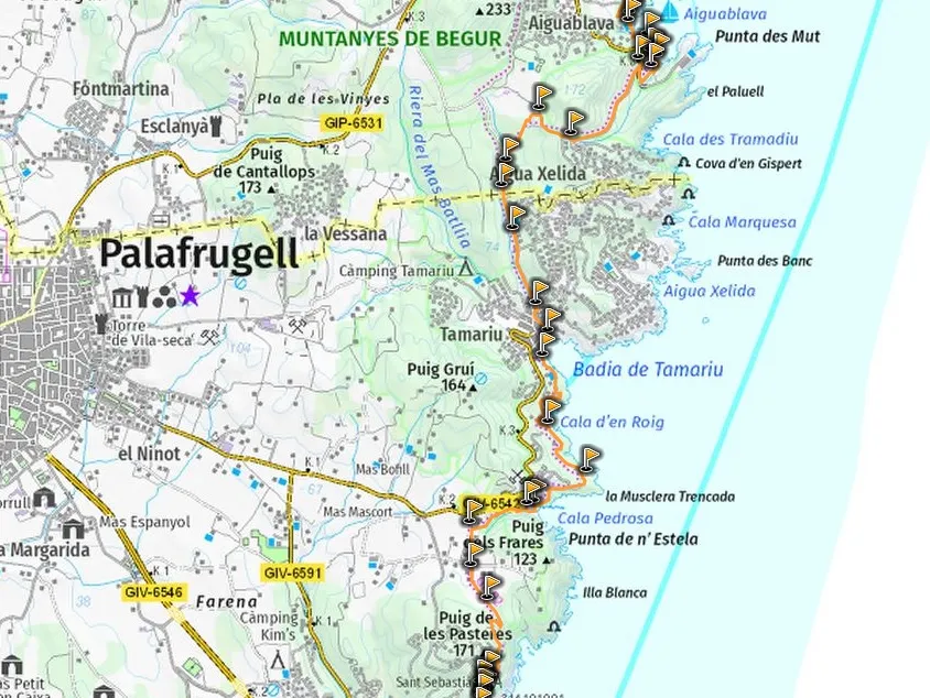
This stage covers the 11 km between Calella de Palafrugell and Aiguablava or Fornells, depending on where you choose to stay. Accommodation ranges from boutique hotels to a well‑located campsite. After the long, rewarding first day, this stage feels more balanced: shorter in distance, but packed with viewpoints, coves and classic Camí de la Ronda scenery.
Waking up in Calella de Palafrugell — with the sound of waves against the rocks and fishing boats bobbing in the bay — set the tone for the day. I knew the distance ahead was manageable, but also that this stage included some of the most beautiful coves on the entire route. The kind of places where progress slows because you simply have to stop and swim.
Camí de la Ronda Vocabulary
When talking about place names, I use local Catalan vocabulary:
- Cala – Cove
- Camí – Path
- Cap – Headland
- Castell – Castle
- Platja – Beach
- Far – Lighthouse
- Poblat Ibèric – Iberian settlement ruins
- Torre – Watchtower
- Mirador: viewpoint
Image Gallery For Camí de la Ronda DAY 2 in Costa Brava
Click on any of the 97 images to open full screen gallery player. Note that viewing images is subject to our Fair Use Policy.
Visiting Camí de la Ronda DAY 2 in Costa Brava
As you’re reading this, I hope you take my advice and do this as a three‑day trip. For you, Day Two begins with fresh legs and a good night’s sleep in Calella de Palafrugell. For me, this section was the torturous end of Day One — because I had originally (and unwisely) planned the route as a two‑day hike with an overnight in Tamariu.
Leaving Calella de Palafrugell via the steps at the end of Platja Els Canyissos, the route climbs onto a paved coastal path along rocky bluffs, passing the iron sculpture Mirador de Carles Sentís. This stretch is full of viewpoints, Mediterranean flowers and glimpses of Torre de Calella de Palafrugell, now privately owned. As the path curves around the Llafranc headland, Mirador de Llafranc offers a sweeping view over another postcard‑worthy fishing town.
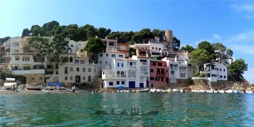
Llafranc is a small, elegant town with plenty of hotels and hostels — a viable overnight stop if you want to break the route differently. Platja de Llafranc is a wide, calm beach lined with restaurants, including Nomo Mar, a Japanese‑Mediterranean fusion spot. At the far end of the beach, the GR‑92 continues via a staircase leading to a viewpoint over the bay. Unfortunately, the next section is a road climb through a hilltop urbanisation because the headland, Cap de Sant Sebastià, has been carved up by private estates.
This road section lasts about 30 minutes but is steep and exposed. I was already exhausted from the previous day and had to stop several times on the ascent. Eventually, I reached the summit at Far de Sant Sebastià, a white lighthouse now converted into the restaurant Far Nomo, sister to Nomo Mar. Nearby is El Far Hotel Restaurant, a beautifully restored Catalan farmhouse with a terrace bar overlooking the sea.
Behind the hotel are the historic monuments of Ermita de Sant Sebastià de la Guarda and Torre de Sant Sebastià de la Guarda. Both date from the 18th century and are open to the public. The hermitage is a small stone chapel; the tower is a museum with a rooftop terrace offering 360‑degree views. Despite my fatigue, I paid the small fee and climbed to the top — absolutely worth it. Adjacent to the tower are the foundations of the Poblat Ibèric de Sant Sebastià de la Guarda, where the street layout of the ancient settlement is still visible.
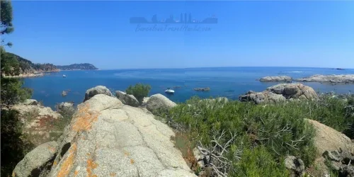
Leaving the tower and Iberian village, the path follows the coastline briefly before turning inland through pine forest and past a wheat field. Here the route makes a sharp right turn, descending a forested river valley toward a small hut. As you pass it, the view suddenly opens to Cala Pedrosa, a cliff‑lined cove with a stony beach and clear, refreshing water. There’s a small beach bar at the back of the cove, and I highly recommend swimming here — it’s intimate, quiet and beautifully sheltered. When you’re ready to leave, take the rock‑cut stairs on the left side of the beach (facing the sea) and follow the pine‑forest path parallel to the coast.
The forest trail eventually transitions into a paved path, signalling the approach to another picture‑perfect coastal village. The route descends onto Platja dels Liris, marking your arrival in Tamariu. This small village has a fishing pier, several hotels and hostels, and a well‑located campsite. When I attempted this as a two‑day hike, I stayed here — after 18 km, dinner on the beachfront overlooking the bay felt like a reward. The sound of waves against the rocks at night was incredibly calming, and I slept deeply. But in hindsight, compressing the route into two days meant rushing past too many beautiful beaches. As a three‑day hike, you’ll have time to enjoy them properly — even to take a one‑hour kayak trip with Kayaking Costa Brava Tamariu.
Leaving Tamariu, the GR‑92 heads inland rather than along the coast, again due to private developments blocking the original path. The ascent through pine forest is steady but offers excellent views from a summit viewpoint. Exiting the forest onto a road, the route descends into Aiguablava, a cove whose name — “blue water” — is no exaggeration. Platja d’Aiguablava is a sandy beach framed by cliffs, with restaurants and bars behind it. Toc al Mar is particularly well‑known for its seafood and wine selection, and I recommend stopping here.
If you’re following my recommended three‑day itinerary, Aiguablava is the ideal place to spend the night. The bay has one main hotel, the Parador d’Aiguablava, while the neighbouring village of Fornells offers boutique hotels, hostels and apartment rentals.
Recommended swimming spots between Calella de Palafrugell and Aiguablava/Fornells: Llafranc Beach, Cala Pedrosa, Platja de Tamariu and Platja d’Aiguablava.
Hiking The Camí de la Ronda with a dog
Dogs are not permitted on beaches from 1 June to the last Sunday in September, except in designated dog zones. Day Two includes several beaches that are not dog‑friendly in summer, so it’s best to complete this stage outside the peak season.
The route combines rocky paths, pine forest and some paved sections. In spring, summer and early autumn, be aware of poisonous Pine Processionary Caterpillars. Aside from this seasonal hazard, the terrain presents no particular difficulties for dogs.
You will not have a bad meal in Aiguablava or Fornells — you will have amazing food and outstanding dining experiences.
-
🌐 Toc al Mar: cosy beachfront restaurant specialising in grilled fish, seafood and paella.
📍 Platja d’Aiguablava, 17255 Girona -
🌐 Restaurant Les Acàcies: large beachfront restaurant with terrace dining, offering seafood, paella and grilled meats.
📍 Platja d’Aiguablava, 17255 Girona -
🌐 Restaurante Mar i Vent: elegant restaurant at the Parador serving seafood, paella and grilled fish.
📍 Platja d’Aiguablava, 17255 Girona
What to take with you for Camí de la Ronda DAY 2 in Costa Brava
This stage is best enjoyed with a light pack. You’ll be walking along beaches, rocky paths and forest trails in warm weather, so carry only what you need. A small daypack is enough if you’re staying in hotels each night.
- Lightweight hiking shoes or trail runners
- Swimwear
- Microfibre towel
- Sun protection
- 2–3 litres of water
- Snacks
- IPX8 waterproof phone pouch
- Small dry bag
Camí de la Ronda DAY 2 in Costa Brava Summary of Prices
Train/Bus Fare
Entry Ticket
Additional Information
Train/Bus Fare
Entry Ticket
Additional Information
Adult
€ 17.45
FREE
Child
€ 17.45
FREE
Getting to Camí de la Ronda DAY 2 in Costa Brava
Address: Callela de Palafrugell, Callela de Palafrugell, 17210
The northern Costa Brava has no rail service, so the most practical way to reach these coastal towns is by bus. Moventis Sarfa‑Bus operates route 100, which connects Barcelona with the main villages along this section of the Camí de Ronda.
Because this is a linear three‑day hike, travelling by bus works well:
- Day 1: Bus to Palamós (Estació de Autobuses) → walk to Calella de Palafrugell or Llafranc (overnight).
- Day 2: Walk from Calella de Palafrugell or Llafranc to Aiguablava or Fornells (overnight).
- Day 3: Walk from Aiguablava or Fornells to Begur (Plaça Forgas) → bus back to Barcelona.
Note: The bus times shown on my route map were accurate on the day I completed this hike. Moventis Sarfa‑Bus may adjust schedules depending on season and demand, so always check current times and prices before travelling.
The outbound journey on Day 1 is from Barcelona–Estació Nord to Palamós–Sarfa. The return journey on Day 3 is from Begur–Plaça Forgas back to Barcelona–Estació Nord.
Wikiloc Trail for Camí de la Ronda DAY 2 in Costa Brava
Please sign in with Google to view the Wikiloc Route map.
Sign in with GoogleWeather for Camí de la Ronda Callela de Palafrugell
Where to stay in Aiguablava or Fornells
The challenge with finding accommodation in Aiguablava or Fornells is securing a one‑night booking, which is why I recommend looking at hotels slightly outside the beachfront area or considering bungalows in nearby campsites.
- Parador de Aiguablava — cliff‑top hotel with spectacular views.
- Hotel Aigua Blava — elegant hotel a short walk from the beach.
- Hotel Eetu — adults‑only hotel in Fornells.
- Hotel Nuevo Ondina — simple, well‑located option.
- Hostal Ondina — budget‑friendly rooms.
- L’Aixart Aiguablava Hotel — stylish boutique hotel.
Nearby Attractions to Camí de la Ronda DAY 2 in Costa Brava
 BUS
BUS
3k views
Camino de la Ronda – Day 1 of 3 on the Costa Brava
A 12 km GR‐92 coastal hike from Palamós to Calella de Palafrugell, passingcoves, viewpoints and classic Costa Brava scenery on the first day of this 3‑day route
Read more >
 BUS
BUS
2.8k views