Collioure to Banyuls‑sur‑Mer – Côte Vermeille Coastal Hike
Hike the Côte Vermeille from Collioure to Banyuls‑sur‑Mer: rugged cliffs, turquoise coves, Cap Béar lighthouse and unforgettable Mediterranean views
Views:
3.1k
About Collioure to Banyuls-sur-Mer Coastal Hike
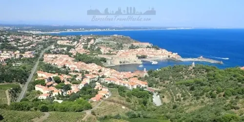
This is the Côte Vermeille at its wildest — a coastline carved by wind, salt and sun, where every headland reveals another hidden cove and every climb rewards you with a new sweep of Mediterranean blue. The hike from Collioure to Banyuls‑sur‑Mer is one of the most exhilarating coastal routes in southern France: a 17‑kilometre journey across cliff‑top trails, lighthouse ridges, vineyard‑covered hillsides and beaches so clear you’ll want to drop your pack and dive straight in.
You start in Collioure, a colourful French‑Catalan harbour town that feels like it was built for postcards — terracotta roofs, a medieval castle, and a bay full of fishing boats. Within minutes you’re climbing out of town, gaining height fast as the rooftops fall away and the sea opens up beneath you. The trail rolls along the cliffs toward Port‑Vendres, a working port with a proud maritime history, before pushing you back into the wild: cannons, old fortifications, and rugged paths that cling to the coastline.
From here the adventure ramps up. The ascent to Cap Béar is a highlight — a dramatic lighthouse perched above a deep‑blue bay dotted with boats. The wind hits you, the views explode open, and suddenly the Côte Vermeille feels huge. The trail then drops into a series of coves and beaches, each one more tempting than the last: Paulilles, Forat, Elmes… turquoise water, smooth rock shelves, and perfect spots to cool off mid‑hike.
The final stretch into Banyuls‑sur‑Mer is pure Mediterranean joy — a rolling balcony path above the sea, vineyards climbing the hillsides, and the town slowly coming into view with its long beach and palm‑lined promenade. By the time you reach the train station, you’ll feel like you’ve walked through an entire coastline’s worth of landscapes in a single day.
This is a route for hikers who want movement, scenery and a bit of grit — steep climbs, rocky descents, and the kind of coastal terrain that keeps your legs working and your heart full. It’s challenging, rewarding, and unforgettable.
If you love dramatic coastlines, lighthouse viewpoints, wild coves and the feeling of earning your swim — this hike is for you.
Image Gallery For Collioure to Banyuls-sur-Mer Coastal Hike
Click on any of the 43 images to open full screen gallery player. Note that viewing images is subject to our Fair Use Policy.
Visiting Collioure to Banyuls-sur-Mer Coastal Hike
This linear route begins in Collioure. Head south along the beachfront promenade until you reach Tour d'Avall, then follow the main road as it climbs out of town with the sea opening up beside you. A viewpoint along this road gives you a final sweeping look back over Collioure’s bay before the trail turns wilder. Continue until a roadside parking area, where a footpath drops down to Plage des Batteries.
Because the houses in this area sit right on the edge of the cliffs, the best option is to follow the hamlet roads to Plage de l'Huile (Platja de l'Oli). From here, you can either take the footpath behind the houses or stay on the road a little longer to reach Plage d'en Baux (Platja d'en Baus). These beaches are tempting, but the real gems lie further along the wild coastline beyond the urban stretch.
The route weaves between coastal paths and residential areas before descending into Port‑Vendres. Walking along the marina, you’ll find cafés, bakeries and shops — a perfect place to grab breakfast or refill water. Port‑Vendres is an active fishing port with a lively atmosphere. At the inland end of the marina you’ll pass the 18th‑century Obélisque, built to honour King Louis XVI and celebrate American independence, as well as the Romanesque façade of Santa Maria de Portvendres (1888).
Continue around the marina and out of town through an industrial dock area. This section isn’t the most scenic, so it’s best to keep a brisk pace. When you spot disused railway tracks embedded in the road, take the left turn — a shortcut path that runs alongside the tracks and avoids a longer road section.
Stay on the road until you reach a left turn onto a gravel track by the coast. Here you’ll pass several Napoleonic cannons guarding the port entrance and a monument A la mémoire des militaires français disparus. The track leads to Plage de l’Anse de l’Espéluga, a beach sheltered by a breakwater. It’s a pleasant spot, but better beaches await.
Behind this beach, look for a footpath climbing away from the road. This avoids traffic and quickly rewards you with views of Sémaphore du Cap Béar, a lighthouse and semaphore station surrounded by old military ruins. The base of the lighthouse is a superb viewpoint — and a rare patch of shade for a snack.
From here the trail enters one of the most dramatic sections of the entire route. The path rises and falls along raw, jagged cliffs around Anse de Sainte‑Catherine, offering some of the best untouched coastal scenery on the Côte Vermeille. Follow the Sender – Sentier Cap de Biarra and enjoy the crystal‑blue water below as the trail crosses a rugged headland.
The path drops into the tiny cove of Plage de l’Olympe, then continues to Anse de Thil — one of my favourite places for a swim. After cooling off, continue along the coastline to Plage de Bernardi, a wider beach and another excellent swimming spot. Nearby Paulilles Beach is also beautiful, but for me the most special is the more secluded El Forat Beach a little further along.
Leave the beach on the gravel track toward Fort Ullastrell at the tip of the headland. The trail then crosses open shrubland along the cliffs before reaching the outskirts of Banyuls‑sur‑Mer at Plage du Sana and Plage des Elmes. Follow the road up to the roundabout and join the main coastal road.
The final highlight is a viewpoint and picnic area marked by the Vogue – Claude Gomez monument. From here you get a fantastic panorama over Banyuls‑sur‑Mer before descending to the town’s main beach and promenade. If time allows, this is another great place for a swim.
This is a medium‑hard route along rugged coastline shaped by wind and weather. Expect plenty of ascents and descents as the trail dips in and out of coves, beaches and headlands.
Allow 6–8 hours to complete the route.
Hiking from Collioure to Banyuls‑sur‑Mer with a Dog
This route is absolutely doable with a dog, but there are a few seasonal rules and practical realities to keep in mind. Along the Côte Vermeille, dogs are generally not permitted on beaches between the 1st June and the last Sunday in September, except in designated dog zones. Because this hike crosses several beaches and busy coves, it’s best to keep your dog on a leash during the summer months, especially when passing through the more popular swimming areas.
In the smaller, quieter coves where people aren’t bathing, it’s sometimes possible to let your dog cool off in the water — but use your judgement and be respectful of other beachgoers. If you want a more relaxed experience with fewer restrictions, consider doing this hike outside the peak summer season.
The terrain itself is a mix of sandy beaches, rocky paths and cliff‑top trails. Most dogs handle it well, but the rocky sections can be hot underfoot in summer and the constant ascents and descents can be tiring for older or less active dogs. Bring plenty of water for them, especially on hot days.
In spring and summer there is a low chance of encountering Pine Processionary Caterpillars. These are dangerous to dogs, so keep an eye out when passing pine trees and avoid letting your dog sniff or investigate anything on the ground that looks like a caterpillar cluster.
What to take with you for Collioure to Banyuls-sur-Mer Coastal Hike
This route spends a lot of time close to the water — beaches, coves and cliff‑top paths — so it’s worth packing with the sea in mind. Anything you don’t want getting wet should go inside a waterproof bag inside your rucksack. I also carry my phone in an IPX8 case so I can take photos from the water without worrying about splashes.
The trail is exposed for long stretches with very little shade, so bring 2–3 litres of water depending on the season. There are places to refill in Port‑Vendres, but once you leave the town you’re committed to the coastline until Banyuls‑sur‑Mer.
Footwear should be comfortable on mixed terrain — the route alternates between sandy beaches, rocky paths and uneven cliff sections. In summer, the rocks can get hot underfoot, so good grip and breathable shoes make a big difference.
As with any coastal hike, sun protection is essential: hat, sunglasses and high‑factor sunscreen. The wind can be deceptive along the headlands, and it’s easy to underestimate how strong the sun is.
If you plan to swim (and you should — the coves are incredible), pack a lightweight towel and swimwear. Many hikers simply wear quick‑drying clothes and go straight in.
Beyond that, the usual essentials apply: a small first‑aid kit, snacks, and a fully charged phone with offline maps. The route is well‑marked, but having your own navigation is always reassuring.
Collioure to Banyuls-sur-Mer Coastal Hike Summary of Prices
Train/Bus Fare
Entry Ticket
Additional Information
Train/Bus Fare
Entry Ticket
Additional Information
Adult
€ 42.00
€ 0.00
Child
€ 42.00
€ 0.00
Notes
Train Fare starts from 42 Euros, Hike is Free
Getting to Collioure to Banyuls-sur-Mer Coastal Hike
Address: Chem. du Cap Bear, Port-Vendres, France, 66660
There are two straightforward ways to reach Collioure from Barcelona by train:
- Barcelona‑Sants → Perpignan (1h 22min), then an SNCF local commuter train from Perpignan to Collioure (20min).
- Barcelona‑Sants → Cerbère (France) on the slower Regional R11 service (2h 37min), passing Barcelona‑Passeig de Gràcia, Sant Andreu Comtal, Sant Celoni, Girona, Figueres and Portbou. From Cerbère, take the SNCF local train to Collioure (15min).
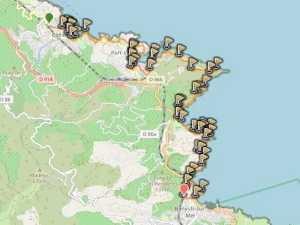
See the Collioure to Banyuls‑sur‑Mer train map in the documents section for more details.
Portbou station is unusually large for such a small fishing village. When it was built, it served as a major frontier station with full border checks and customs between France and Spain, comparable in scale to Barcelona’s mainline stations. Today, with both countries integrated into the EU, the hard border no longer exists and the station feels almost empty. If you’re travelling via the R11 and have more than an hour between the French train and the Rodalies service back to Barcelona, there are several bars and restaurants just outside the station where you can grab dinner.
By Car (recommended strategy): Drive to Collioure and park there for the day. Then take the train two stops to Banyuls‑sur‑Mer and hike the route in reverse back to your car. Parking is available at Parking de la Gare or Parking Le Glacis. Expect around €15 for 24 hours.
Documents for Collioure to Banyuls-sur-Mer Coastal Hike
Wikiloc Trail for Collioure to Banyuls-sur-Mer Coastal Hike
Please sign in with Google to view the Wikiloc Route map.
Sign in with Google