Montsant Escaladei & Clot del Cirer 15km Circular Hike
Spectacular 15km circular hike from Escaladei Monastery through Montsant cliffs, chain‑assisted ravines, high plateaus and the Clot del Cirer natural spring
Views:
1.8k
About Montsant Escaladei & Clot del Cirer
The Montsant mountain range rises just 20km inland from Tarragona and forms part of the Catalan Pre‑Coastal Range, right in the heart of the DO Priorat wine region. Its highest peaks — Roca Corbatera (1163 m), Pilo dels Senyalets (1109 m) and La Cogulla (1063 m) — dominate the landscape with dramatic cliffs, natural caves and a vast rocky plateau. The name Serra de Montsant, meaning “Holy Mountain Range”, comes from the many hermits who lived here during the early Medieval period. Today, the area is protected as Montsant Natural Park.
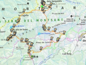
This 15km circular route begins at the Cartoixa d’Escaladei Monastery Museum, a beautifully restored Carthusian monastery at the foot of the sierra. Founded in 1194 under King Alfonso I, Escaladei became one of the wealthiest monastic centres in Catalonia thanks to land ownership, grape cultivation and wine production. Its influence shaped much of the region now known as Priorat.
At its peak in the 16th and 17th centuries, the monastery underwent major architectural expansion. But from the 19th century onward, church land confiscations and civil uprisings led to its abandonment and eventual ruin. Today, Escaladei is partially restored and open to visitors — a fascinating starting point for this mountain route. Allow 30–60 minutes to explore before beginning the hike.
The trail climbs from the monastery through terraced vineyards and the abandoned monastic site of La Pietat, before reaching the base of the Cingles de Montsant cliffs. Several ravines here require short chain‑assisted scrambles. Once on the plateau, the route crosses a landscape of rocky scrubland and summits including Punta Alta del Boter (1007 m), La Guardiola (1014 m) and La Cogulla (1062 m). Between La Guardiola and La Cogulla lies a large natural cave often used by mountain goats for shelter.
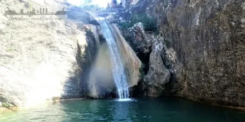
The descent leads into the natural basin of Clot del Cirer, a circular depression with a seasonal spring and small caves around its perimeter. From here, the route climbs back to the plateau and follows a spectacular cliff‑top path at Roca de Miso, offering sweeping views of the Montsant cliffs and the vineyards below. The final section descends through forest and returns to the monastery.
Image Gallery For Montsant Escaladei & Clot del Cirer
Click on any of the 73 images to open full screen gallery player. Note that viewing images is subject to our Fair Use Policy.
Visiting Montsant Escaladei & Clot del Cirer
This is one of the most spectacular routes in the Montsant Natural Park, and I’ve completed it three times. The best seasons are early September — when the Priorat grape harvest fills the valley with activity — or any time in autumn and winter, when the coastal influence keeps the mountains free of snow and the air crisp and clear.
From the entrance of the Cartoixa d’Escaladei Monastery, take the ascending gravel road to the left. At the top, bear left again to join a footpath that climbs through terraced vineyards. Follow the trail across a mix of footpaths and gravel tracks until you reach the abandoned monastic site of La Pietat. Shortly after, the route passes the old stone bread oven of Font del Rosalí.
The trail continues up the lower slopes of the sierra, switching between forest paths and wider tracks as it approaches the base of the Cingles de Montsant cliffs. This is where the route becomes more technical and exciting. A rocky traverse beneath the cliffs leads to a short ravine scramble over large boulders, assisted by fixed chains.
The path then climbs gently along a ledge of striking red rock, passing several small caves before reaching the chain‑assisted ascent of Grau de l’Escletxa. This narrow passage between two huge rock walls leads to a smooth 5‑metre slab climb, again aided by chains. It’s short but memorable.
At the top, follow the ledge to the left and make another brief climb to reach the Punta de Boter summit sign and viewpoint — an ideal place to stop and take in the panoramic views of the Montsant cliffs and the Priorat landscape.
The next section crosses a rocky scrubland plateau dotted with small hills such as La Guardiola and Punta Alta. In this area you’ll find a natural cave large enough to enter, often used by goats as shelter and a perfect spot for a snack break.
Continue along the mostly flat ridge until the marked left turn for La Cogulla. The path passes through a naturally formed fissure in the rock, and it’s possible to climb the final two metres to the summit for another outstanding viewpoint. From here, follow the ridge along the Serra Major until the indicated descending turn.
The trail drops into a dry riverbed that leads into the circular rock basin of Clot del Cirer. This natural depression contains a seasonal spring and several small caves around its perimeter — a peaceful, sheltered place to rest.
From Clot del Cirer, follow the dry riverbed back up to the ridge at Pi de Cugat. Soon the path begins descending the Grau de Salfores, following another dry river channel to the dramatic viewpoint of Racó de Miso, where you’ll enjoy sweeping views from the top of the cliffs. The trail then bends right along the cliff edge before descending a series of switchbacks into the forest.
The final section winds through woodland and eventually joins a gravel track that leads back to the monastery and the starting point of the route.
This hike includes several short ravine climbs with chains and requires hands‑and‑feet scrambling, so it is not suitable for anyone uncomfortable with exposure or steep ascents. It is possible to complete it with a dog, but you will need a dog harness and a short rope to assist on the chain sections. Large dogs may struggle with the vertical steps.
Allow 6–8 hours to complete the full loop. A medium level of fitness is required.
For a perfect weekend, you can combine this hike with a second day exploring the dramatic cliffs and natural pools of Siurana, staying overnight in the village.
Hiking Montsant Escaladei & Clot del Cirer with a Dog
This route is mostly forested, with long stretches of oak, beech and pine woodland, and open shrubland on the higher plateau. In autumn and winter it’s an excellent dog‑friendly hike — cool temperatures, stable weather and no snow. If you see pine trees in spring or summer, be aware that there may be pine processionary caterpillars, which are dangerous for dogs.
The main challenge for dogs is the series of chain‑assisted scrambles on the ascent. The first involves climbing over large boulders in a ravine, and the second is a narrow rock passage followed by a 30‑degree slab climb using chains. Small and medium dogs can usually manage these sections with help, but you will need to lift or guide them at least once.
I’ve completed this route with a small dog, and the chain sections were manageable with a dog harness and some teamwork. The dog was able to climb the inclined slab without assistance, but the boulder scramble required lifting. For larger dogs, bring a 4‑metre rope and ensure you have at least two people capable of supporting the dog safely. Very large or heavy dogs may struggle with the vertical steps.
The rest of the route — the plateau, the ridgeline and the descent — is straightforward for most dogs, though the rocky terrain can be tough on paws. Bring plenty of water for your dog, as Montsant is a dry mountain range and there are no reliable springs except Clot del Cirer.
Cartoixa d'Escaladei Monastery Museum Opening Hours & Tickets
The Cartoixa d’Escaladei is partially restored and open to visitors throughout the year. It’s the perfect place to explore before starting the Montsant circular route, and you should allow 30–60 minutes to walk through the cloisters, chapels and restored monastic cells.
Opening Hours
- 16 December – 28 February: 10:00 to 16:00
- 1 March – 31 May: 10:00 to 17:30
- Easter Weekend (Fri–Sun): 10:00 to 19:00 Easter Monday: 10:00 to 17:30
- 1 June – 30 September: 10:00 to 20:00
- 1 October – 15 December: 10:00 to 17:30
- Closed: Non‑festive Mondays, 25–26 December, 6 January
Note: The ticket office closes 30 minutes before the monastery’s closing time.
Ticket Prices
- €5 — Adults aged 16–65
- €3 — Seniors (65+), students, Carnet Jove holders, and groups of 10+
- Free — Under 16s, disabled visitors, tour guides, and members of the Associació de Museòlegs de Catalunya, International Council of Museums, or International Council of Monuments
- Free entry — Last Tuesday of every month from 1 October to 30 June
Poboleda Grape Harvest Festival
The first Saturday of September, the village of Poboleda celebrates one of the most charming traditions in the Priorat wine region — a grape harvest festival that recreates the old‑fashioned methods of picking and pressing grapes. It’s an ideal cultural complement to the Montsant Escaladei hike, especially if you’re visiting during the early autumn harvest season.
The day begins at dawn, when visitors can join local families in the vineyards to help gather grapes by hand. After the harvest, everyone returns to the village for a communal open‑air breakfast, a long‑standing tradition that brings together locals, winemakers and travellers.
Later in the morning, the freshly picked grapes are crushed in the traditional way — barefoot, in large wooden vats — accompanied by music, dancing and plenty of laughter. The festival continues with stalls from local wineries offering tastings of DOQ Priorat wines, along with artisanal products and regional food.
Poboleda’s narrow streets, stone houses and festive atmosphere make this one of the most authentic wine‑culture events in Catalonia. If you’re planning to hike Montsant in early September, combining the route with the Poboleda harvest festival turns the trip into a memorable weekend of nature, history and wine.
Where to eat and drink
The hamlet of Escaladei has no bars or restaurants, so it’s best to stop in the nearby village of Poboleda for breakfast, coffee or a post‑hike meal. Both options below open early enough to fuel up before starting the Montsant circular route.
-
El Cau — A friendly roadside bar‑restaurant open from 9:00 to 15:00. Ideal for a simple breakfast or coffee before heading to the monastery.
T‑702, 6, 43376 Poboleda, Tarragona -
Local Social La Closa — A village bar and restaurant open from 8:00 or 9:00 until 16:00, and until midnight on weekends. A good choice for both pre‑hike breakfasts and relaxed post‑hike meals.
Carrer Sant Jaume, 24, 43376 Poboleda, Tarragona
What to take with you for Montsant Escaladei & Clot del Cirer
This is a rugged mountain hike with chain‑assisted scrambles, rocky ledges and exposed ridgelines, so packing the right gear makes a huge difference to comfort and safety. Montsant is a dry, wind‑prone sierra, and the terrain is far more technical than it appears from the valley.
I always prepare for wind on this route. The plateau and cliff‑top sections are fully exposed, and gusts can be strong even when the lower vineyards feel calm.
Carry 2 to 3 litres of water. Montsant is an extremely dry mountain range, and the only natural water source — the spring at Clot del Cirer is the only refill point along the route.
Wear sturdy hiking boots with good grip. The chain sections, boulder scrambles and ravine climbs require solid traction. Lightweight trail runners are not ideal unless you’re very confident on technical rock.
A windproof or lightweight waterproof jacket is essential. Even in autumn and winter, the combination of altitude and exposure can make the ridge surprisingly cold.
Bring sun protection — hat, sunglasses and sunscreen. The limestone reflects light strongly, and the plateau offers little shade.
Montsant Escaladei & Clot del Cirer Summary of Prices
Train/Bus Fare
Entry Ticket
Additional Information
Train/Bus Fare
Entry Ticket
Additional Information
Adult
€ 20.00
FREE
Child
€ 20.00
FREE
Group/Family Ticket?
Cartoixa d'Escaladei monastery museum 10+ people 3 Euros entry
Notes
Walk is free, Cartoixa d'Escaladei monastery museum 5 euros entry
Getting to Montsant Escaladei
Address: Rambla de la Cartoixa S/N, Escaladei, 43379
The Montsant Escaladei circular route is located deep in the Priorat region, and unlike other natural parks in Catalonia, it is not served by public transport. There are no buses or trains that reach Escaladei or the surrounding hamlets, so the only realistic way to access the trail is by car.
The drive from Barcelona takes around 2 hours, following the AP‑7 and AP‑2 motorways before turning inland through the Priorat wine country. The final stretch winds through vineyards and small villages, offering a scenic approach to the monastery.
When you arrive, park outside the gates of the Cartoixa d’Escaladei Monastery. The monastery closes its gates at the end of the day, and if your car is inside the enclosure, it may be locked in until the next morning. Parking just outside the entrance ensures you can return from the hike at any time without issues.
Documents for Montsant Escaladei & Clot del Cirer Hiking
Wikiloc Trail for Montsant Escaladei & Clot del Cirer
Please sign in with Google to view the Wikiloc Route map.
Sign in with GoogleWeather for Montsant Escaladei
Mountain Forecast weather for Serra de Montsant