Aragon Rivers II – Hiking Congost de Mont‑rebei Canyon
Hike the cliff‑side trail of Congost de Mont‑rebei with turquoise waters, suspension bridges, and the Montfalcó stairs leading to the Montfalcó hostel
Views:
2.2k
About Congost de Mont-rebei Hiking
Some hikes stay with you because of their beauty. Others because of their exposure. Congost de Mont‑rebei stays with you because it is both — a place where turquoise water slices through a 500‑metre‑deep canyon, and where a narrow path carved into the cliffside pulls you into one of the most dramatic landscapes in the pre‑Pyrenees.
About three hours inland from Barcelona, the Noguera Ribagorçana river marks the border between Catalonia and Aragón as it winds through the Serra de Montsec natural park. Here, the mountains close in to form a 20‑metre‑wide gorge — a natural corridor of vertical limestone walls, suspension footbridges, and the world‑famous Montfalcó stairs bolted directly into the rock.
This is one of the last great wild canyons of the region: no roads, no power lines, no artificial viewpoints. Just a cliff‑cut trail, a handful of tunnels, and the constant drop of turquoise water far below. Every turn reveals something new — a balcony viewpoint, a tunnel exit perched above the void, or a glimpse of the red Montfalcó suspension bridge glowing against the rock.
Whether you hike only the canyon section or continue all the way to the Montfalcó hostel for an overnight stay, this route is unforgettable. It’s not technically difficult, but it demands attention: narrow ledges, exposed sections, and long staircases fixed to the cliff make this a hike for those comfortable with heights.
Congost de Mont‑rebei is more than a trail — it’s a journey through geology, silence, and scale. A place where every step feels carved from the mountain itself.
Image Gallery For Congost de Mont-rebei Hiking
Click on any of the 51 images to open full screen gallery player. Note that viewing images is subject to our Fair Use Policy.
Visiting Congost de Mont-rebei Hiking
The hiking route begins at the La Masieta parking area (42.097516N, 0.6982146E), just outside the village of Puente de Montañana. From the parking area, follow the GR1 along the Camí de Congost de Mont‑rebei, passing the small shop and information point.
The trail crosses the Barranc del Pinell via a wooden footbridge before entering a shaded forest section. The path curves around a rocky bluff and opens onto the first panoramic views of the turquoise reservoir below.
Continue along the GR1 to reach the first suspension bridge. Only three people should be on the bridge at a time to minimise movement, especially for hikers with mild vertigo. This bridge spans a small inlet that, in wetter years, carries water into the main Noguera Ribagorçana river.
After the bridge, the trail re-enters the forest and narrows to a metre-wide ledge in places. This section requires attention: the path is exposed, with a steep drop to the water below. Metal cable handholds are installed along the cliff wall where the ledge is tightest.
The route then enters the famous Camí Vell de Congost de Mont‑rebei — the cliff‑cut section of the canyon. Here, the path is carved directly into the limestone wall, passing through short tunnels and balcony viewpoints. Benches and lookout points appear along the way, offering safe places to stop and enjoy the views.
Partway through the canyon, a steep side path branches off toward the Cova de Colomera. This optional detour involves a short chain‑assisted scramble and adds around 30 minutes. The cave is enormous and offers one of the best natural viewpoints over the gorge.
Back on the main trail, the canyon gradually widens and transitions into a forested descent. You’ll reach two forks — in both cases, take the right‑hand path signposted for Puente Montfalcó. The trail soon reveals the striking red Montfalcó suspension bridge, which crosses a narrow pinch point in the gorge.
After crossing the bridge, the path climbs a rocky slope with several viewpoints looking back toward the canyon. At the top of this climb, the trail appears to end — but look closely and you’ll see the start of the iconic Montfalcó stairs. These wooden staircases cling to the vertical cliff in multiple flights, descending all the way to the base of the wall. They are protected on the open side but require steady footing and patience.
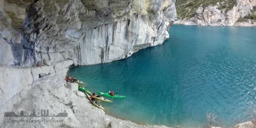
At the bottom of the stairs, continue along the Camí de Montfalcó al Congost de Mont‑rebei. Shortly ahead, a small side path on the left leads down beneath an overhanging cliff. When reservoir levels are high, this area forms a natural beach — a good place for swimming and resting.
If you are completing this as a one‑day hike, this is the recommended turnaround point. Return to La Masieta via the same route.
If you are doing the hike as a two‑day route, continue uphill through the forest to reach the Montfalcó hostel for an overnight stay. A short path from the hostel leads to the Ermita de Santa Quiteria, a small hilltop chapel with wide views over the Montsec range. Just before the hostel, you will pass the Font de Montfalcó, a natural spring that may be dry depending on the season.
Congost de Mont-rebei as an Organised Package Tour.
For guided hiking experiences, see the Tickets section for recommended tours.
Congost de Mont-rebei as a Self Organised Trip
This route includes narrow cliff‑side paths, exposed ledges, suspension bridges and the Montfalcó stairs. It is not suitable for hikers with vertigo. Take care at all times, especially in the canyon section.
For booking details for the Montfalcó hostel, see the accommodation section of the Congost de Mont‑rebei weekend getaway page.
Hiking Congost de Mont-rebei with a dog
The trail surface is gravel and rock, which may be tough on paws depending on your dog’s experience. The canyon section is narrow with steep drops, and the Montfalcó stairs can be challenging or impossible for some dogs. You will also need to carry your dog across the two suspension bridges, which have metal mesh flooring.
Vegetation is mostly scrub and small trees, with a short pine section. The risk of encountering pine processionary caterpillars is low but not zero.
What to take with you for Congost de Mont-rebei Hiking
For hiking the Congost de Mont‑rebei and the Montfalcó stairs, you will need basic hiking gear and enough water for a full‑day route. The trail includes exposed cliff‑side sections, suspension bridges and long staircases, so appropriate footwear and sun protection are essential.
Backpack & Water
- 30L hiking rucksack – enough capacity for water, food, layers and essentials.
- 3 litres of water – minimum recommended for a full‑day hike; there are no reliable refill points.
- Dry bag or waterproof pouch – optional, but useful for protecting electronics.
Clothing
- Comfortable hiking shorts or trousers – avoid loose fabric in exposed sections.
- Breathable T‑shirt or long‑sleeve top – for sun protection.
- Sturdy hiking boots or trail shoes – essential for grip on gravel and rocky terrain.
- Hat or cap – recommended for sun protection.
- Swimwear – optional, useful if you plan to swim near the natural beach below the Montfalcó stairs.
Sun & Weather Protection
- Sun cream – essential; the canyon and stair sections offer limited shade.
- Sunglasses – helpful on bright days.
- Lightweight windproof layer – optional, depending on season.
Safety & Extras
- Fully charged phone – coverage is limited but useful for navigation and emergencies.
- Small first‑aid kit – plasters, blister care, basic supplies.
- Snacks or packed lunch – no services along the route.
The trail includes exposed cliff‑side sections, suspension bridges and the Montfalcó stairs. Ensure your footwear has good grip and avoid carrying loose items that could fall from height.
Congost de Mont-rebei Hiking Summary of Prices
Train/Bus Fare
Entry Ticket
Additional Information
Train/Bus Fare
Entry Ticket
Additional Information
Adult
€ 25.00
€ 25.00
25€ based on 4 people sharing an apartment
Child
€ 25.00
€ 25.00
25€ based on 4 people sharing an apartment
Group/Family Ticket?
25€ based on 4 people sharing an apartment & 20€ for an evening meal
Getting to Congost de Mont-rebei Hiking
Address: Congost de Mont-rebei, Aparcamiento de la Masieta, Puente de Montañana, Huesca, 22584
The main access point for kayaking Congost de Mont‑rebei is the La Masieta parking area. During high season (15 July to 11 September), parking costs €8 per car per day, and advance booking is recommended due to limited capacity.
To reach La Masieta, leave the N‑230 and cross the Noguera Ribagorçana river onto the C‑1311 just before entering the village of Puente de Montañana. Continue along the C‑1311 for approximately 6 km until you reach the signposted turn‑off for La Masieta. Follow this road downhill to the parking area.
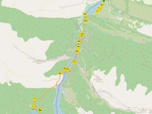
Wikiloc Trail for Congost de Mont-rebei Hiking
Please sign in with Google to view the Wikiloc Route map.
Sign in with Google