Warning: Undefined array key "HTTP_ACCEPT_LANGUAGE" in /home/barcjkkl/public_html/App/Config/MySQL/language.php on line 32
Deprecated: explode(): Passing null to parameter #2 ($string) of type string is deprecated in /home/barcjkkl/public_html/App/Config/MySQL/language.php on line 36
Tavertet Molí Bernat Waterfall and Morro del Abella Viewpoint
One of the most emblematic hikes in Catalonia under a waterfall via a cliff path with ladders & spectacular viewpoints of panta de Seu Reservoir
Updated: Nov 22, 2024by: Barcelona Travel HacksViews: 3k
About Tavertet Molí Bernat waterfall & Morro del Abella
This is a hiking route that I have done three times because it is that special. It has everything: Waterfalls, amazing cliff path with forested valley views, Multiple viewpoints from high rock formations, ladder ascents in one section, a river crossing in a forest, a hidden cave and a steep forest ascent into the rock cliff with viewpoints of the Panta de Seu Reservoir dam.
This is not a route for anyone that has difficulty with vertical ascents via a 3m ladder or suffers from vertigo.
The paths are not always marked so I will provide a detailed description of the route below.
Leaving the village of Tavertet via a road that is along the top of a cliff with spectacular views of the valley bellow, the Panta de Seu Reservoir dam and lake plus the rolling mountains in the distance. The route takes a small footpath down into the valley behind the village and into a forested section before arriving at the crescent shaped waterfall path that cuts under the overhanging Salt del Molí Bernat waterfall above.
The Salt del Moli Bernat waterfall is usually dry or has a small cascade of falling water. Following this waterfall path leads to the Molí Bernat mill ruins with mill stone placed nearby for artistic effect. Passing the mill ruin via several small wooden bridges over the mill stream takes us to a T-junction in the path where turning right is a rocky uphill ascent and left is the continuation of the route.
An optional part of this route is to first turn right because this path takes us up to the top of the waterfall and a stone bridge over the river, Pont del Molí Bernat. This is habitually a dry river as you can see in the photos but does provide good views down the valley. Return back to the T-junction and follow a very narrow path going down into a forest.
Continue along this forest trail until reaching a point where it makes a turn to the right and climbs up the cliff in a zig-zag fashion. This is not the right way and leads to an impassable dead end higher up in the cliff face. Backtrack and you will see that the path actually continues straight on through the forest ducking down to pass low branches.
At this point you will start to emerge from the forest and be on a narrow footpath with the yellow-coloured rock on your right and a sloping drop on your left. Continue along this path until reaching two green 4m ladders bolted to the cliff face. Climb up the ladders to find the continuation of the path.
With a grey and sometimes yellow coloured cliff on the left we pass what appears to be small natural caves or alcoves that have been shaped to provide basic human habitation. Keep a look out on the left for a headland jutting out. Before getting to a small stream there is path that goes down and out to this headland. This is a good point to stop and have snacks while enjoying the views.
The route from here continues along the cliff side path and dips back into a forest. A little further along you will see a tree with rope that provides a hand rail of sorts for an ascending path going up into the Cova de pixarelles cave. This is an optional deviation of about 10 metres up into the cave but is worth the effort. Take care if you chose to ascend to the cave as the path is steep and slippery in parts.
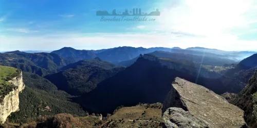
Once back on the cliff side path, Cingles de Perereda, continue following it until you see, in front up high, a rock formation jutting out from the cliff. You may even see hikers on top. When you see this keep an eye out for a path on the right that zig-zags up the valley in a forest via steep rocky path. When you get to the top you will see that the path is flat and goes to the left and you will see the top of the Morro de L'Abuela narrow rock headland. Take care along here as there are high falls all around but spectacular views of the Panta de Seu Reservoir and on the right another large waterfall called Salt de Trabous. This is the most spectacular viewpoint along this route and a fantastic place for photos.
Once finished at Morro de L'Abuela backtrack down the path taken to ascend from the cliff side path and continue along this path going down into the forest until arriving at a Riera de Balá river crossing. To the right of this crossing are some natural pools where I swim but the water is very cold!
After the natural pools follow the path across the river and pay close attention here because it is easy to get a little lost. You are looking for a short steep forested path that goes up to a gravel road. All other paths lead nowhere so you may have to back track a little if you take the wrong path.
At the gravel road turn right and follow it for a few kilometres until the route indicates an unmarked path on the left leading up the forest slope towards the cliffs. This is a steep long zig-zag ascent called Puig de la Forsa (strong push!) through the forest that will arrive at a flat section in the forest where paths merge in a cross shape with a wooden marker post. Take the left path from where you came up. You will know you are on the correct path when through the trees you see the Panta de Seu Reservoir.
You will also see an old stone wall and a path with old stone steps. Take these steps up and you will get to another great viewpoint of the Panta de Seu Reservoir. This path goes under an overhanging rock formation and along the side of the cliff. Further along, the path seems to come to an end but actually takes a left turn up into another short zig-zag path which lands on a gravel road.
Congratulations, you have completed all the hard parts of this route. Turn right on this road and follow it parallel to the top of the cliffs. There are multiple viewpoints along the way. Further along will see a caravan in a field with chairs and tables. This is La Cantina de Virupa which serves vegan snacks and locally produced wine. At this point Tavertet village is another 2km along this easy, mostly flat gravel road so I always indulge myself with a glass or two of wine here!
Image Gallery for Image Gallery For Tavertet Molí Bernat waterfall & Morro del Abella
Click on any of the 86 images to open full screen gallery player
❮❯
Visiting Tavertet Molí Bernat waterfall & Morro del Abella
This is a very good route for autumn or early winter. I recommend doing it as day two of a two day weekend with the first day being Rupit, 30 minutes (20Km) drive from Tavertet. It can also be done as a single day hiking activity being under 2 hours drive from Barcelona.
Overnight accommodation can be found in Rupit village. My recommendations are to stay in Rupit Hotel/hostal Estrella or Camping Rupit. There is also accommodation in Tavertet Alzina apartments or renting the Can Vila house if you want to stay there overnight.
Allow 6-9 hours to complete the route depending on personal fitness.
Hiking Tavertet Molí Bernat Waterfall and Morro del Abella with a Dog
This is fun and challenging route for a dog that is predominantly through forest and shrub of oaks, beeches and some pines that are in The Collsacabra mountains. If you see Pines in the spring or summer then there may be poisonous Pine Processionary Caterpillars. However, I recommend this as a late summer hike so there is a low probability of coming across Pine Processionary Caterpillars but, as always, I recommend diligence.
It is viable to do this route with a dog and I have done it with a small dog. Note that there is a 3m vertical ladder to ascend a cliff face along the route so I advise a dog harness and, just in case, 4m of rope to assist in lifting the dog up. if your dog is large and cannot be lifted between two people then this route is probably not viable. At the Morro del Abella cliff top viewpoint there are sheer drops of at least 50m so I recommend putting your dog on a leash here.
What to take with you for What to take with you for Tavertet Molí Bernat waterfall & Morro del Abella
This is a Medium-Hard walking route in the mountains around Tavertet Hamlet. I always do it with a small rucksack of the essentials and first aid kit. Emergency waterproof jacket is recommended.
Take 2 to 3 litres of water.
Pack a spare pair of socks in case that you get your feet wet while crossing one of the rivers.
Take a head torch for autumn hiking.
Tavertet Molí Bernat waterfall & Morro del Abella Summary of Prices Summary of Prices
Train/Bus FareEntry TicketAdditional InformationTrain/Bus FareEntry TicketAdditional InformationAdult€ 20.00€ 0.00Child€ 20.00€ 0.00NotesAccessible by car. Parking 1 Euro per day.
Getting to Tavertet Molí Bernat waterfall & Morro del Abella
Address: BV-5707, Tavertet, 08511
Tavertet is a village that is served by an on-demand bus provided by Sagales with the bus running from L'Esquirol. This would mean a train then two busses to get to Tavertet by public transport. I have always done this hiking route travelling by car to Tavertet.
By car from Barcelona: Take the C-17 to Vic, there join the C-25 towards Girona, exit 183 towards Roda de Ter via the C-153. Cross Roda de Ter in the direction of Olot. At l'Esquirol take the BV-5207 to Tavertet. Allow 1h:45m minutes for this journey.
By car from Girona: Take the C-25 towards Lleida and take exit 183 towards Roda de Ter via the C-153. Cross Roda de Ter in the direction of Olot. At l'Esquirol take the BV-5207 to Tavertet.Allow 1h:25m minutes for this journey.
Tavertet Hamlet is pedestrianised with parking at the entrance to the Village which costs 1 euro per day. Pay at the ticket machine next to the parking entrance barrier.