Tarragona to Tamarit GR‑92 Coastal Walk with Beaches & Coves
Easy 14 km GR‑92 coastal walk from Tarragona to Tamarit with wild coves, Waikiki Beach, pine forest trails, abandoned ruins and views of Tamarit Castle
Views:
4k
About Tarragona to Tamarit Castle GR-92 Costa Dorada Coastal walk
This stretch of coastline between Tarragona and Tamarit is one of those rare places where the city dissolves almost instantly into nature. Within minutes of leaving the station you’re on a rocky path above turquoise water, following the GR‑92 through pine forests, quiet coves and long sandy beaches that feel far more remote than they really are. It’s the perfect route when you want a coastal hike that delivers beauty without the commitment of a full‑day trek — a shorter, easier version of the Torredembarra to tarragona walk, but with just as much charm.
You’ll pass abandoned hospital ruins reclaimed by nature, viewpoints where the sea crashes below your feet, and hidden coves like Waikiki where the water is shallow, warm and impossibly clear. The trail ends at Tamarit Castle, one of the most dramatic silhouettes on the Costa Dorada, perched above a sheltered beach that feels made for a final swim. With easy train access at both ends, this is a route that invites you to slow down, swim often and enjoy a coastline that still feels wild.
This route is an EASY 14Km Linear coastal route following the GR-92 from Tarragona to Tamarit and Altafulla, similar to the Torredembarra to Tarragona route but not as long and done in reverse.
Vila dels Munts History
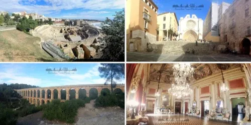
Vila Romana dels Munts is one of the best‑preserved Roman villas in Catalonia and offers a rare glimpse into the luxurious coastal lifestyle of the Roman elite. Built in the 1st–2nd century AD, it was the seaside residence of a high‑ranking provincial official, complete with private baths, mosaics, frescoes and landscaped gardens overlooking the Mediterranean. Walking through the site you can explore the remains of the thermal complex, the residential quarters, storage areas and the impressive bathhouse foundations. It’s a place where you can clearly imagine Roman governors relaxing by the sea, and it adds a fascinating layer of historical depth to the hike — a reminder that this coastline has been lived in, worked on and admired for nearly two thousand years.
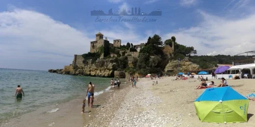
Castell de Tamarit
Castell de Tamarit is one of the most striking landmarks on this route — a fortified medieval castle rising directly above the sea, its walls merging with the cliffs that protect Cala Jovera. The origins of the castle date back to the 11th century, when it served as a defensive stronghold for the Archbishop of Tarragona during a period of coastal raids and territorial disputes. Over the centuries it evolved into a fortified village with a church, watchtower and walled precinct, guarding both the coastline and the mouth of the Gaià River.
Today, Castell de Tamarit is privately owned and used as an exclusive venue for weddings and events, which is why access inside the walls is restricted. Even so, the castle remains a highlight of the hike — a dramatic backdrop to the beach, a reminder of the region’s medieval past, and one of the most atmospheric points along the GR‑92.
Image Gallery For Tarragona to Tamarit Castle GR-92 Costa Dorada Coast
Click on any of the 96 images to open full screen gallery player. Note that viewing images is subject to our Fair Use Policy.
Visiting Tarragona to Tamarit Castle GR-92 Costa Dorada Coastal walk
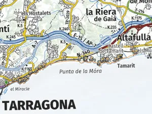
Starting at Tarragona Renfe station, turn right upon exiting the station and use the footbridge to cross over the tracks onto Tarragona beach promenade. Turn left with respect to the sea and continue walking north. The route leaves the city walking along Playa El Miracle. Follow the coastline along the rocky path using the route markers of white posts or red and white trail markers as it goes behind Fortí de la Reina. An 18th‑century fortification built during the reign of Queen Elisabeth Farnese (Isabel de Farnesio), wife of King Philip V, to strengthen Tarragona’s maritime defences. Constructed between 1732 and 1734, it formed part of a broader system of coastal batteries designed to protect the city and its port from naval attack during a period of European conflict and Bourbon consolidation.
The path is a coastline trail behind hoses and crosses Playa De los Cossis then passes Estàtua de Sant Magí.
Sant Magí is the patron saint of Tarragona, venerated as a hermit and miracle‑worker associated with springs and water. According to tradition, he lived as an ascetic in the nearby Brufaganya mountains, where he was martyred in the 3rd century for refusing to renounce his faith. The statue commemorates this local devotion: it represents the saint holding a staff and a water jug, symbolising the miraculous springs he was said to produce during times of drought. The statue stands as a civic reminder of Tarragona’s annual Festa de Sant Magí, when water from Brufaganya is ceremonially brought into the city.
Keep following the coastal rocky path and along this section the geological feature of El bufador d'aigües can be found. it is a small cave that is open to the sea and the sky so a piston effect of water entering the cave on the tide is forced up like a gezer. Cross the next beach Platja de la Rabassada and ascend the rocky path at the end to walk round Arrassaba headland.
Follow the fence line fencline skirting around Preventori de la Savinosa a ruined mid‑20th‑century children’s preventorium on the outskirts of Tarragona. Originally created as a health institution for children at risk of tuberculosis. Over time, however, the centre became associated with serious allegations of mistreatment: former residents have described harsh discipline, neglect, psychological cruelty and physical punishment during their stays. Although the site is now abandoned, its reputation endures as a reminder of the darker side of Spain’s institutional care system during the Franco era.
At the end of the rocky hospital path, drop down onto Savinosa beach and follow it to the end picking up pine forested and shrubland trail around to Platja dels Capellans. at then ed of this beach enter another forested shrubland section then pick up Platja Llarga This 2km long wide sandy beach is best crossed by walking in the shoreline with the waves lapping your feet as you walk.
From this point the route follows another rocky and pine forested path to get to the Cala Fonda, Known locally as Waikiki beach. This is my recommended place to swim. To get to the beach descend a well trodden narrow path in the pine forest. This beach is shallow and you will need to walk out 200 metres or more to be fully in the water. Although not a nudist beach, you can swim naked here if you dare.
Once you have finished at Waikiki beach you can leave by the same path you used to descend or at the northern end is another well worn path that will take you back to the main GR-92 trail in the pine forest and lead onto the next beach of Cala de la Roca Plana and Platja de Calabecs. These are also nudist beaches and also a great intimate place to swim naked.
The trail continues in the pine forest before arriving at some stone steps and a gate. pass through the gate to find Torre de la Móra Despite its medieval look, Torre de la Móra is a 16th‑century watchtower from the era when Catalonia fortified its coastline against Barbary pirates. Follow my indicate route to cross the caravan, bungalows and tents campsite and take a stone path descending down to Platja La Mora. The best way is to cross this beach at the shoreline but it is worth stopping here at Restaurant Móra Mar for lunch.
At the end of the beach is a rocky path ascending into the pine forest that leads up to a stone paved path lined with colourful wild flowers. Follow this path behind the houses until it transitions into rocky path into a forested section interspersed with cliff top viewpoints. A spectacular headland castle will come into view and infront of it you will see a sunny protcted cove with Cala Jovera which is a great place to swim if you want a bright sunny beach.
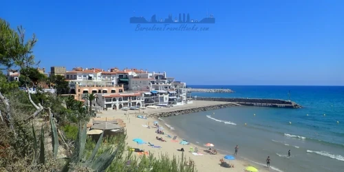
Alternatively, follow the path round the back of the castle passing Antic Pou del Poble de Tamarit, this was the medieval well of Tamarit village. The path transitions into a road that descends down to Platja de Tamarit which is another great place to swim with the castle as a backdrop. you can also get snacks or lunch at Restaurant Brisa next to the castle.
Follow the beach along the shoreline until you see the ruins of a concrete bunker, Búnquer d'Altafulla in the sand that was part of the Francoist coastal fortification programme (1930s–1940s). It served as an observation post and deterrence. walk round the back of the bunker and pick up a gravel trail headin into the village of Tamarit. Walk along the beachfront promenade until you reach a portal, Pont d'Mar. The Pont de Mar has the look of an old Roman wall portal, and its position near the Roman villa of Els Munts makes it tempting to imagine. However, there’s no historical evidence linking it to a Roman wall, so it’s best described as a later seafront portal with a possible defensive purpose.
Cross under the portal and follow the road inland for about 400m to arrive at the station. If yu are doing this route in reverse and arrive in the morning at Altafulla-tamarit there is also time to stop off at the Vila Romana dels Munts roman ruins museum.
If you want to visit the Roman Ruins of Vila Romana dels Munts, in Altafulla they can be found at the northern end of the town. The photos from Vila Romana dels Munts Roman ruins can be found in the Torredembarra to Tarragona page.
Allow 3-4 hours walking time plus any time you want to spend swimming and eating.
Vila dels Munts Opening Hours and Prices
- January, February, November & December:
- Tuesday to Saturday: 10:00 am to 1:00 pm & 3:00 pm to 5:30 pm
- Sunday & Public Holidays: 10:00 am to 2:00 pm
- March, April, May & October:
- Tuesday to Saturday: 10:00 am to 1:00 pm & 3:00 pm to 6:00 pm
- Sunday & Public Holidays: 10:00 am to 2:00 pm
- June, July, August & September:
- Tuesday to Saturday: 10:00 am to 1:00 pm & 3:00 pm to 8:00 pm
- Sunday & Public Holidays: 10:00 am to 2:00 pm
- Closed: Mondays, 25th December, 26th December, 1st January, 1st May, Easter Holidays
- Free entry: 11th November (10:00 am to 2:00 pm), Easter Tuesday
- Last entry: 30 minutes before closing
- Adult ticket: 4 euros
- Reduced ticket: 2 euros — seniors, students, disabled visitors, single‑parent families (with accreditation)
- Free: under 16 years old
Hiking from Tarragona to Tamarit Altafulla with a dog
Dogs are generally not permitted on beaches during the summer season, from 1st June to the last Sunday in September, except in officially designated dog zones. This route includes several beaches that are not dog‑friendly in summer, so it’s best completed with your dog outside of the high‑season restrictions.
For a dog‑friendly experience, complete this route outside the summer beach‑restriction period (1st June to the last Sunday of September). The best months are October to May, which you can also find in the Dog Hiking Calendar.
The walk combines long sandy beaches with rocky coastal paths and shaded pine forest trails. In spring and early autumn you may encounter pine processionary caterpillars, which are dangerous to dogs if touched or inhaled. Aside from this seasonal hazard, the route is straightforward for most dogs and offers plenty of natural shade and soft terrain.
What to take with you for Tarragona to Tamarit Castle GR-92 Costa Dora
Because this route involves long stretches of beach walking and several points where you’ll be close to the shoreline, it’s worth protecting anything you don’t want getting wet. I pack all valuables inside a dry bag inside my rucksack, and I keep my phone in an IPX8 waterproof case so I can take photos even while standing in the sea. If you plan to swim at Waikiki, Cala Jovera or La Mora, this setup makes life much easier.
Bring 2–3 litres of water, especially in warm weather — there are no fountains along the route and very few places to refill outside of beach bars. Lightweight footwear that handles both sand and rocky paths is ideal, and a small microfibre towel is useful if you’re planning multiple swims. In summer, sun protection is essential: a hat, sunscreen and sunglasses will make the exposed sections far more comfortable.
Tarragona to Tamarit Castle GR-92 Costa Dorada Coastal walk Summary of prices
Train/Bus Fare
Entry Ticket
Additional Information
Train/Bus Fare
Entry Ticket
Additional Information
Adult
€ 16.10
FREE
Child
€ 16.10
FREE
Notes
Walk is free, Return train ticket costs 16.10 Euros.
Getting to Tarragona to Tamarit Castle GR-92 Costa Dorada Coastal walk
Address: Altafulla, Altafulla, 43893
Altafulla-Tamarit and Tarragona are served by the R14, R15, R16 and R17 regional RENFE lines, with trains taking around 70 minutes from Barcelona. You can find the full network layout in the train map in the documents section.
The last train departs Tarragona at around 10:00 pm, giving you plenty of time to complete the route without rushing or cutting short your swims in the coves and beaches along the way.
Documents for Tarragona to Tamarit Castle GR-92 Costa Dorada Coastal walk
Wikiloc Trail for Tarragona to Tamarit Castle GR-92 Costa Dorada Coastal walk
Please sign in with Google to view the Wikiloc Route map.
Sign in with GoogleWeather for Tarragona
Where to stay near Tarragona to Tamarit Castle GR-92 Costa Dorada
Nearby Attractions to Tarragona to Tamarit Castle GR-92 Costa Dorada Coastal Walk
 TRAIN
TRAIN
8.9k views
3 Days in Roman Tarragona – Plan the Ultimate City Guide
Explore Roman Tarragona with a 3‑day itinerary covering amphitheatres, forums, walls and UNESCO ruins. The perfect Tarragona guide and an easy day trip from Barcelona
Read more >
 TRAIN
TRAIN
2.9k views
Torredembarra to Tarragona GR‑92 Coastal Walk, Beaches & Ruins
18 km GR‑92 coastal walk from Torredembarra to Tarragona with lighthouses, Roman ruins, Tamarit Castle, wild coves, Waikiki Beach and cliff‑top views
Read more >
 TRAIN
TRAIN
2.5k views