Tavertet Waterfall & Morro de l’Abella Viewpoint Cliff Hike with Cave
Spectacular cliff hike under Molí Bernat waterfall with ladders, forest paths, cave detour, and panoramic views of Panta de Seu Reservoir from Morro de l’Abella
Views:
2.7k
About Tavertet Molí Bernat waterfall & Morro del Abella Viewpoint Hike
This is one of the most emblematic hikes in Catalonia, and I’ve done it three times because it’s that special. The route features waterfalls, a dramatic cliffside path, forested valleys, rocky viewpoints, a hidden cave, and a 4m ladder ascent bolted to the cliff face.
It’s not suitable for hikers with vertigo or difficulty with vertical climbs. Dogs can join, but you’ll need a dog harness and 4–6m of rope to assist them up the ladder. If your dog is the size of a pony, this route isn’t viable!
This is a fantastic autumn or early winter hike. I recommend pairing it with Rupit as a two-day weekend itinerary—Rupit on day one, Tavertet on day two. Both are under two hours from Barcelona by car.
Accommodation options include Hostal Estrella or Camping Rupit in Rupit, and in Tavertet you’ll find Alzina Apartments or the Can Vila house for overnight stays.
Image Gallery For Tavertet Molí Bernat waterfall & Morro del Abella Viewpoint Hike
Click on any of the 86 images to open full screen gallery player. Note that viewing images is subject to our Fair Use Policy.
Tavertet Molí Bernat waterfall & Morro del Abella Viewpoint Hiking Route
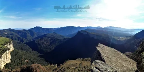
Leaving Tavertet village, the route begins along a cliff-top road with sweeping views of the Panta de Seu Reservoir, its dam, and the surrounding mountains. A narrow footpath descends into the valley and enters a forested section, leading to the crescent-shaped trail beneath the Salt del Molí Bernat waterfall.
This waterfall is often dry or reduced to a gentle cascade, but the overhanging cliff and mill ruins below—Molí Bernat—create a dramatic setting. Cross several small wooden bridges over the stream to reach a junction. Turn right for an optional climb to the top of the waterfall and the Pont del Molí Bernat, a stone bridge offering views down the valley. Return to the junction and continue into the forest.
Follow the trail until it appears to veer right into a zig-zag cliff ascent—ignore this and continue straight, ducking under low branches. You’ll emerge onto a narrow path with yellow rock on your right and a sloping drop to your left. This leads to two bolted 4m green ladders—climb carefully to reach the next section.
With the cliff wall on your left, pass natural alcoves and lookout points. Before reaching a small stream, look for a path leading to a rocky headland—an ideal snack stop with panoramic views. Continue along the cliffside path (Cingles de Perereda) until you spot a rock formation jutting out above. This is the Morro de l’Abella.
Watch for a steep forest path on the right that zig-zags up to the top. The summit offers spectacular views of the reservoir and the Salt de Trabous waterfall. Take extreme care—this viewpoint has sheer drops on all sides.
Backtrack to the cliff path and descend into the forest, arriving at the Riera de Balà river crossing. To the right are natural pools—refreshing but cold! Cross the river and look for a steep forest path leading to a gravel road. If you miss it, backtrack and try again.
Follow the gravel road until you reach an unmarked path on the left. This is the steep zig-zag ascent known as Puig de la Forsa. At the top, paths merge at a wooden marker post—take the left path. You’ll soon see the reservoir through the trees and reach a stone wall with old steps leading to another viewpoint.
The trail continues under an overhanging rock and along the cliff edge. When the path seems to end, look left for a short zig-zag climb to a gravel road. From here, it’s an easy walk along the cliff tops with multiple viewpoints.
Eventually, you’ll spot a caravan in a field—this is La Cantina de Virupa, serving vegan snacks and local wine. Tavertet village is just 2km further along the flat gravel road. I always reward myself with a glass or two here!
Hiking Tavertet Molí Bernat Waterfall and Morro del Abella with a Dog
This is fun and challenging route for a dog that is predominantly through forest and shrub of oaks, beeches and some pines that are in The Collsacabra mountains. If you see Pines in the spring or summer then there may be poisonous Pine Processionary Caterpillars. However, I recommend this as a late summer hike so there is a low probability of coming across Pine Processionary Caterpillars but, as always, I recommend diligence.
It is viable to do this route with a dog and I have done it with a small dog. Note that there is a 3m vertical ladder to ascend a cliff face along the route so I advise a dog harness and, just in case, 4m of rope to assist in lifting the dog up. if your dog is large and cannot be lifted between two people then this route is probably not viable. At the Morro del Abella cliff top viewpoint there are sheer drops of at least 50m so I recommend putting your dog on a leash here.
What to take for Tavertet Molí Bernat waterfall & Morro del Abella Hiking
This is a medium-hard hiking route through the Collsacabra mountains, with cliffside paths, forest ascents, and a vertical ladder section. I always carry a small rucksack with trail essentials and a first aid kit.
Pack an emergency waterproof jacket, especially in autumn or early winter when weather can change quickly. The forest offers shelter, but exposed viewpoints can be windy and cold.
Bring 2 to 3 litres of water. There are no fountains or refill points along the route, and the climb to Puig de la Forsa is long and steep.
Pack a spare pair of socks in case your feet get wet during the Riera de Balà river crossing or in the natural pools.
Carry a head torch if hiking in late autumn, as the forested sections and cliff paths can become dim before sunset.
If hiking with a dog, bring a dog harness and 4–6m of rope to assist with the ladder section.
Tavertet Molí Bernat waterfall & Morro del Abella Summary of Prices
Train/Bus Fare
Entry Ticket
Additional Information
Train/Bus Fare
Entry Ticket
Additional Information
Adult
€ 20.00
€ 0.00
Child
€ 20.00
€ 0.00
Notes
Accessible by car. Parking 1 Euro per day.
Getting to Tavertet Village
Address: BV-5707, Tavertet, 08511
Tavertet village is best reached by car, as public transport options are limited and require multiple transfers. An on-demand bus service operated by Sagalés runs from L’Esquirol, but getting there involves a train to Vic, followed by two bus connections. For simplicity and flexibility, I recommend driving.
- By car from Barcelona: Take the C-17 north to Vic, then join the C-25 towards Girona. Exit at junction 183 for Roda de Ter via the C-153. Continue towards Olot, and at L’Esquirol, take the BV-5207 mountain road to Tavertet. Allow approximately 1 hour 45 minutes.
- By car from Girona: Take the C-25 west towards Lleida and exit at junction 183 for Roda de Ter via the C-153. Continue towards Olot, and at L’Esquirol, take the BV-5207 to Tavertet. Allow approximately 1 hour 25 minutes.
Tavertet is pedestrianised, with designated parking at the entrance to the village. The fee is €1 per day, payable at the ticket machine next to the entrance barrier. For navigation, use this Google Maps parking location.
Documents for Tavertet Molí Bernat waterfall & Morro del Abella Hike
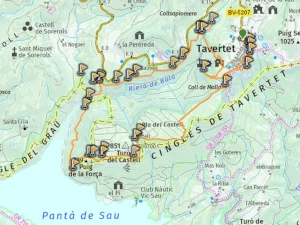
Wikiloc Trail for Tavertet Molí Bernat waterfall & Morro del Abella Viewpoint
Please sign in with Google to view the Wikiloc Route map.
Sign in with GoogleWeather for Tavertet
Mountain Forecast weather for Tavertet