Warning: Undefined array key "HTTP_ACCEPT_LANGUAGE" in /home/barcjkkl/public_html/App/Config/MySQL/language.php on line 32
Deprecated: explode(): Passing null to parameter #2 ($string) of type string is deprecated in /home/barcjkkl/public_html/App/Config/MySQL/language.php on line 36
Colliure to Banyuls-sur-Mer Coastal Hike
17Km meduim Côte Vermeille coastal hike in Southern France via the town of Port Vendres and the Cap bear lighthouse interspersed with beautiful beaches
Updated: Nov 21, 2024by: Barcelona Travel HacksViews: 3.3k
About Collioure to Banyuls-sur-Mer Coastal Hike
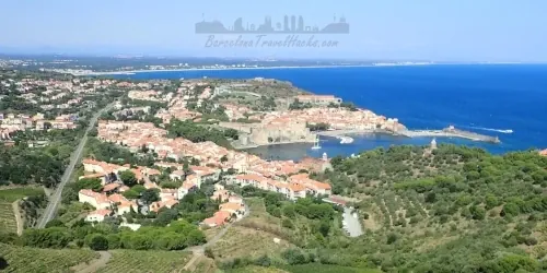
This linear route starts in Collioure leaving the town via paved roads with viewpoints looking back towards Collioure.
Following the road for a while we pick up a coastal trail towards port-Vendres, another historic coastal town with a marina and industrial port. The route continues through the town via the marina and leaves via a paved road towards l'anse de l'Espeluga beach passing via a trail with cannons and small forts.
Behind l'anse de l'Espeluga beach is a trail that leads upwards to a path that parallels the coastline towards Cap bear lighthouse. After visiting Cap bear headland the route follows a rocky trail around Les Ecueils bay and along the top of a cliff on a downwards path to the beutiful Paulilles beach and Forat beach. I recommend swiming in one of these two beaches.
The route next follows the coast to Oullastrell headland which has a fort. This location is another great viewpoint. The trail continues along the coastline along another rocky trail with ascent to Cap d'Ullastrell headland then descent down to Cap Castell de Vello headland. The path continues along the clifftop descending down to Sauna beach and cove then Elmes beach and cove.
Here the route follows a paved coastal road around Banyuls-sur-Mer to a viewpoint of this town. Once level with the main beach of this town we take a road inland towards the train station.
Image Gallery for Image Gallery For Collioure to Banyuls-sur-Mer Coastal Hike
Click on any of the 43 images to open full screen gallery player
❮❯
Visiting Collioure to Banyuls-sur-Mer Coastal Hike
This is a medium-hard route along rugged natural coastline shaped by wind and rain. The route has a lot of descents and ascents in and out of the various coves, beaches and headlands.
Allow 6 to 8 hours to complete the route.
If travelling via the R1 through Portbou and there is more than one hour between trains, Just outside of Portbou station are several bars and restaurants to get dinner.
Hiking from Colliure to Banyuls-sur-Mer Coastal with a dog
In general Dogs are not permitted on beaches in the summer season between 1st June to the last Sunday in September, except in designated dog zones. This route involves walking along beaches and wild cliff top coastline. If you hike this route in summer season I recommend putting your dog on a leash when crossing the busy beaches. In the smaller coves where people are not bathing it may be possible to swim with your dog in summer. Alternatively you can do this route before the start of summer with a dog.
This route is a combination of sandy beaches and rocky paths with a low chance in spring or summer of finding poisonous Pine Processionary Caterpillars.
What to take with you for What to take with you for Collioure to Banyuls-sur-Mer Coastal Hike
This route involves walking along beaches and close to the shore so I put things that I want to remain dry inside waterproof bag inside my rucksack. I keep my phone inside an IPX8 case so I can take photos from the sea.
Take 2 - 3 litres of water.
Collioure to Banyuls-sur-Mer Coastal Hike Summary of Prices Summary of Prices
Train/Bus FareEntry TicketAdditional InformationTrain/Bus FareEntry TicketAdditional InformationAdult€ 42.00€ 0.00Child€ 42.00€ 0.00NotesTrain Fare starts from 42 Euros, Hike is Free
Getting to Collioure to Banyuls-sur-Mer Coastal Hike
Address: Chem. du Cap Bear, Port-Vendres, France, 66660
There are two ways of getting to Collioure from Barcelona by train:
Barcelona-Sants to Perpignan (1h 22min) then SNCF local commuter train from Perpignan to Collioure. (20 min)
Slower Regional R11 train from Barcelona-Sants to Cerbère (France), passing via Barcelona-Passeig de Gracia, Barcelona-Sant Andreu Comtal, Sant Celoni, Girona, Figueres and Portbou terminating in Cerbère. (2h 37min) From Cerbère a SNCF local commuter train to Collioure. (15 min)
See the Collioure to Banyuls-Ser-Mer Train Map in the documents section for more information.
If visiting Collioure by car, Free parking can be found at Collioure train station, Parking de la Gare, and pay parking, Parking Le Glacis in the centre of town. This is a linear route so you will have to use the train to get back to Collioure.
3 Documents for Collioure to Banyuls-sur-Mer Coastal Hike
Wikiloc Trail for Wikiloc Trail for Collioure to Banyuls-sur-Mer Coastal Hike
a0279 - Colliure to Banyuls-sur-Mer Coastal Hike
17Km Medium-hard Linear Cote Vermeille (France) coastal hike via Port Vendres & Cap bear lighthouse along rocky exposed coastal path with beautiful beaches.