Warning: Undefined array key "HTTP_ACCEPT_LANGUAGE" in /home/barcjkkl/public_html/App/Config/MySQL/language.php on line 32
Deprecated: explode(): Passing null to parameter #2 ($string) of type string is deprecated in /home/barcjkkl/public_html/App/Config/MySQL/language.php on line 36
Hiking the Camí de Ronda GR-92 Coastal Trail
How to follow the Camí de Ronda hiking trail as a series of stunning day hikes. The best bits of the Gr-92 Catalan Coastal trail
About a Weekend Getaway - Costa Brava I - Camí de Ronda
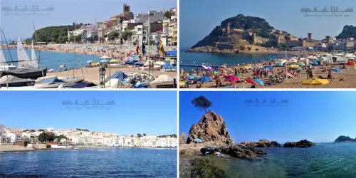
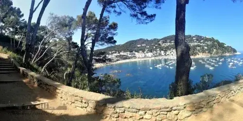
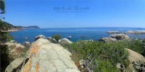
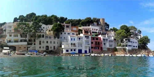
Catalonia has 580 kilometres of intense blue Mediterranean Sea coastline, made up of quaint whitewashed towns and villages, cities and wilderness. I have hiked almost all of the interesting towns and wilderness sections and my favourite is the 33-kilometre section of the Costa Brava Camí de la Ronda trail between Palamós and Begur. This public footpath offers memorable landscapes traversing rugged cliffs, picture perfect calas (coves), Iberian village ruins, castle ruins and dips in and out of postcard picturesque historic fishing villages in between stretches of pine forest backed wilderness.
The Camí de Ronda coastal hiking trail runs from France down the whole of the Spanish coastline, with the most famous section through the Catalan Costa Brava. The best coastal trails in Spain can be found on the 583 Km long section of the Catalan GR-92 Camino de la Ronda with this section being the jewel of the route.
El Camí de la Ronda is characterised by sweeping forests and jagged cliffs that conceal hidden bays and picture-perfect coves for a hiking based weekend getaway. Escape the crowded beaches in towns and cities to find amazing beaches in the summer or complete the trails for an off season hike. You will discover the Catalan coast from a unique perspective while enjoying healthy open air and the cleanest Mediterranean crystal clear blue water.
El Camí la Ronda, or to give it its official name, The GR-92, Gran Recorrido 92, can be divided into sections on the Costa Brava and Costa Dorada and at various points the GR-92 heads inland away from the coast around large urbanisations like Barcelona.
Camí de la Ronda Vocabulary
When talking about place names, I use local Catalan vocabulary:
- Cala - Cove
- Camí – path (camino in Spanish)
- Cap – Headland
- Castell – castle
- Platja – beach
- Far – Lighthouse (Faro in Spanish)
- Poblat Ibèric - Iberian tribe village ruins, some archaeologically dated to 5000 BC
- Torre – Tower, normally round stone watchtowers that were often visual semaphores
Camí de la Ronda History
The Camí de la Ronda is a series of small pathways connecting one cove to the next, historically to enable fisherman, smugglers, sailors, travellers, lighthouse keepers and traginers (cart and mule drivers), to work this once remote coastal territory.
After the Spanish Civil War (1936 to 1939), Spain was in economic Ruin and smuggling was rife so the national police (Spanish Guardia Civil) patrolled the coastline along the Camí de la Ronda until the country stabilised. During the Era of the General Francisco Franco Dictatorship, from the 1950’s, Spain began to open up to tourism and the Camí de la Ronda gained prominence as a popular Costa Brava hiking trail and tourist destination.
Spain has introduced laws (Ley de Costas España) in the early 2000’s to protect the littoral areas from urbanisation by large hotel complexes and wealthy individuals. Some sections of Camí de la Ronda, designated as the GR-92 trail, have now been restored back to the coastal route where they were previously diverted inland around hotels and private residences.
This page is about a two or three day trip to walk the most popular section of the Camí de La Ronda GR-92 trail between Palamós and Begur on the Costa Brava.
Happy Exploring!
3 Attractions in Costa Brava I - Camí de Ronda
Camí de la Ronda DAY 1 in Costa Brava
Camí de la Ronda DAY 1 of 3 hiking 12 Km from Palamós to Callella de Palafrugell in the costa Brava via the GR-92 trail
Read more >
Camí de la Ronda DAY 3 in Costa Brava
Camí de la Ronda DAY 3 of 3 hiking 14 Km from Aigua Blava-Fornells to Begur castle in the costa Brava via the GR-92 trail
Read more >
Map of Costa Brava I - Camí de Ronda
Attractions
Tickets for Costa Brava Tours
If my self organised three day trip to the Costa Brava seems a bit too daunting, try one of the below organised one day guided tours from Barcelona to the town of Sant Feliu de Guíxols.
Powered by GetYourGuide
Powered by GetYourGuide
Getting to Weekend Getaway on Costa Brava I - Camí de Ronda
Address: Palamós, Girona 17230
The start town of Palamós and end town of Begur are both accessible via the SarfaBus-Moventis bus network using the more sustainable travel option of public transport and not a private car. Also, because the route is linear you do not have to hike the same section of coast twice to return to a car.
I completed the Costa Brava section of Camí de la Ronda from Palamós to Begur as a three day mini-break with overnight stays in towns along the coast.
Doing this as a three day trip means that it is viable to get the bus without rushing to get the last bus home after only one day. Also by using the Bus the start and end point can be different, whereas with a car only circular routes can be done.
- Day 1 12Km: Get bus to Palamós and walk to Callella de Palafrugell or LLafranc staying overnight.
- Day 2 11Km: Walk from Callella de Palafrugell or LLafranc to Aiguablava or Fornells staying overnight.
- Day 3 10km: Walk from Aiguablava or Fornells to Begur getting bus back to Barcelona.
Alternatively, this section coastline can be done as a two day trip but does involve more distance each day. I did this as a two day trip and I arrived at my overnight stop physically exhausted and at 7pm with enough time to get a shower, diner and sleep.
- Day 1 18km: Get bus to Palamos and walk to Callella de Palafrugell, LLafrancstaying then Tamariu for an overnight stay.
- Day 2 15km: Walk from Tamariu via Aiguablava, Fornells and Aiguafreda to Begur getting bus back to Barcelona.
Notes:
- The times on my bus route map in the documents section are valid on the day that I did this trip and SarfaBus-Moventis may change times depending on demand. Use the below link to consult times and prices and buy your tickets.
- Outbound journey on day one is from Barcelona-Estacio Nord to Palamos-Sarfa bus stop. The return bus stop in Begur is Begur-Plaza Forgas to Barcelona-Estacio Nord.
- Barcelona-Estacio Nord is the main bus terminal near Arc de Triomf. See the Public Transport Guide - Estacio Nord section for more information about the bus terminal.
Where to Eat Along the Costa Brava between Palamós & Begur
There is an abundance of restaurants along this section of the coastline and here are my recommendations:
Palamós
- Can Pujol Restaurante: located on Cala de la Fosca beach ius an ideal place to stop for breakfast.
Passeig de la Fosca, 19, 17230 Palamós, Girona
Calella de Palafrugell
- Restaurant Fiego: Resataurant found on Platja del Port Pelegrí serving seafood, paella, grilled meat and has an extensive wine list.
Platja del Port Pelegrí, 17210 Calella de Palafrugell, Girona - Margarita: five star seafront restaurant serving Mediterranean food with postcard views.
Carrer Calau, 10, 17210 Calella de Palafrugell, Girona - Gelpifish: Seafood and grilled meats. Great beachfront restaurant for an evening meal.
Carrer de les Voltes, 11, 17210 Calella de Palafrugell, Girona - La Blava: beachfront restaurant in a pituresque whitewash walled and blue doors and windows former fisherman's house. Outside dining on the vaulted seafront galleries. Intimate location. Seafood and grilled meat menu.
Carrer de les Voltes, 11, 17210 Calella de Palafrugell, Girona - Puerto Limón: Terrace restaurant above Platja del Canadell. Seafood and grilled meats. Great beachfront restaurant for an evening meal.
Carrer de Pirroig, 28, 17210 Palafrugell, Girona - Tragamar: Terrace restaurant above Platja del Canadell. Seafood and grilled meats.
Carrer de les Voltes, 11, 17210 Calella de Palafrugell, Girona - Tragamar: Terrace restaurant above Platja del Canadell. Seafood and grilled meats.
Carrer de les Voltes, 11, 17210 Calella de Palafrugell, Girona - Calau Bar: meat skewers & tapas served in terrace bar with sea views.
Carrer de les Voltes, 2, 17210 Calella de Palafrugell, Girona - Pizzeria Vent de Mar: Pizza and pasta cooked in stone bake oven using vegetables grown in the garden.
Carrer de Pirroig, 2, 17210 Palafrugell, Girona - Restaurant Xabec: Mediterranean food in a large airy indoor dining room.
Carrer Lladó, 6, 17210 Calella de Palafrugell, Girona
Llafranc
- Chez Tomàs: Dine on seafood an grilled meat in a Mediterranean garden or inside lounge.
Carrer de Lluís Marquès Carbó, 2, 17211 Llafranc, Girona - Restaurant León: five star seafront restaurant serving Mediterranean food with postcard views.
Carrer de Pere Pascuet, 30, 17211 Llafranc, Girona - Hostal La Llagosta: Family run hostel with beachfront restaurant for grilled fish and meat dishes.
Carrer de Francesc de Blanes, 24, 17211 Llafranc, Girona - Marmara Llafranc: Seafood and grilled meat menu as well as some vegan options.
Carrer de Santa Rosa, 3, 17211 Llafranc, Girona - Puerto Limón: Terrace restaurant above Platja del Canadell. Seafood and grilled meats. Great beachfront restaurant for an evening meal.
Carrer de Pirroig, 28, 17210 Palafrugell, Girona - Nomo Mar: Upmarket sushi and Japanese inspired meat dishes.
Passeig de Cipsela, 10, 17211 Llafranc, Girona - Blau Llafranc: Beach front restaurant serving tapas, seafood and meat mains.
Passeig de Cipsela, 18, 17211 Llafranc, Girona - La Sirena Bar: Beach front bar serving tapas, seafood and meat mains.
Passeig de Cipsela, 31, 17211 Llafranc, Girona - La Caleta de Llafranc: Beach front bar serving tapas, seafood and meat mains.
Passeig de Cipsela, 40, 17211 Llafranc, Girona - Far Nomo: Upmarket sushi and Japanese inspired meat dishes in a restaurant about 15minute walk outside of town in the lighthouse building.
Passeig de Pau Casals, 64, 17211 Llafranc, Girona - Far Nomo: Catalan restaurant in hotel nexto to Llafranc lighthouse. Tapas, seafood and grilled meat from cliff top restaurant terrace.
Muntanya de Sant Sebastià, 17211 Llafranc, Girona
Tamariu
- Restaurant de Cala Pedrosa: Small family run restaurant on the intimate beatuful cala pedrosa bay beach.
Cala pedrosa bay, 17212 Near Tamariu, Girona - Boleru Tamariu: Take away poke bowls including Vegan options.
Carrer del Salí, 2, 17212 Tamariu, Girona - La Morera Port Platja: Beach front bar overlooking small fishing marina serving tapas, seafood and meat mains.
Passeig del Mar, 18, 17212 Tamariu, Girona - El Palanquí: Beach front bar overlooking small fishing marina serving tapas, seafood and meat mains.
Passeig del Mar, 29, 17212 Tamariu, Girona - Bar Rodondo: Beach front bar overlooking small fishing marina serving Tapas, paella, seafood and griled meat..
Carrer del Salí, 2, 17212 Tamariu, Girona - Restaurant Es Dofí: Beach front bar in former fishermans house overlooking small fishing marina serving Tapas, paella, seafood and griled meat..
Passeig del Mar, 22, 17212 Tamariu, Girona
Aiguablava & Fornells
- Mar i Vent: Terrace restaurant overlooking the beach. breakfast, lunch and dinner. seafood and meat dishes.
Playa de Aiguablava, Carrer Platja d'Aiguablava, 17255, Girona - Les Acàcies: Terrace restaurant overlooking the beach. breakfast, lunch and dinner. Tapas, seafood and meat dishes plus pizza and pasta.
n° 3, Carrer Platja d'Aiguablava, 17255 Girona - Toc al Mar: Lobster, paella & oak-fired fish in beach front restaurant with colorful tables outside.
Carrer Platja d'Aiguablava, 8, 17255 Begur, Girona - Aigua Blava: Hotel restaurant with terrace dining of sea views. Catalan seafood and meat dishes.
Carretera Fornells, s/n, 17255 Begur, Girona
Sa Tuna & Aiguafreda
- Hostal Sa Tuna: beach front hostel restaurant serving Mediterranean cuisine of a wide variety of tapas and the best paella.
Passeig de l'Àncora, 14, 17255 Sa Tuna, Girona - Restaurant Es Furió: beach front restaurant serving Tapas, paella, seafood and grilled meat.
Passeig de l'Àncora, S/N, 17255 Sa Tuna, Girona - Xiringuito Aiguafreda: beach hut bar servig tapas and drinks.
Carrer Aiguafreda, 64, 17255 Aiguafreda, Girona
Begur
- Bar de Plaça: Restaurant with terrace dining overlooking the stone church. Tapas, seafood and large selection of grilled meats.
Passeig de l'Àncora, 14, 17255 Sa Tuna, Girona - L'autèntic: highly rated restaurant serving tapas, burgers and some vegetarian options.
Carrer de Campuig, 1, 17255 Begur, Girona - Diferent Restaurant: Luxuary dining presenting dishes to share, rice specialties and tasting menus.
Carrer Pi i Ralló, 10, 17255 Begur, Girona - La Pizzeta:Rustic pizzas, filled pastas and grilled mains served in a building from the 1800s with leafy courtyard dining area.
Carrer Ventura Sabater, 4, 17255 Begur, Girona - Casa Juanita:Tapas & fresh catch of the day seafood cooked in a wood-fired Mediterranean oven and served in a rustic dining room with a vaulted brick ceiling.
Carrer Pi i Ralló, 7, 17255 Begur, Girona
12 Documents for Weekend Getaway to Costa Brava I - Camí de Ronda
Click on any of the PDF thumbnails to view in full screen and download
Weather for Palafrugell
What to take with you for What to take with you for a Weekend Getaway to Costa Brava I - Camí de Ronda
This route involves walking along beaches and close to the shore so I put things that I want to remain dry inside waterproof bag inside my rucksack. I keep my phone inside an IPX8 case so I can take photos from the sea.
I recommend taking 2 - 3 litres of water per day to complete this three part route.
Wikiloc Trail for Wikiloc Walking Routes for the Camí de Ronda from Palamós to Begur
a0175 - Camí de la Ronda GR-92 - Palamós to Calella de Palafrugell - DAY 1
Day 1 of a three day walking route along the most beutiful section of the costa Brava via the GR-92 trail known as la Ronda. Start in Palamos and end in Callella de palafrugell.
Distance: 11.77 Km
Difficulty: Easy
Return Travel Fare: €17.45
Transport Network: Moventis Bus
a0176 - Camí de la Ronda GR-92 - Calella de Palafrugell to Aiguablava - DAY 2
Day 2 of a three day walking route along the most beutiful section of the costa Brava via the GR-92 trail known as la Ronda. Start in Callella de palafrugell and end in Aiguablava or Fornells.
Distance: 10.85 Km
Difficulty: Easy
Return Travel Fare: N/A
Transport Network: N/A
a0177 - Camí de la Ronda GR-92 - Aiguablava to Begur - DAY 3
Day 3 of a three day walking route along the most beutiful section of the costa Brava via the GR-92 trail known as la Ronda. Start in Aiguablava or Fornells and end in Begur.
Distance: 10.11 Km
Difficulty: Easy
Return Travel Fare: €19:85
Transport Network: Moventis Bus
Where to stay overnight Between Palamós & Begur
When thinking about accommodation there are three categories:
- Glamping: Luxury tenting where the tent is provided by the campsite and furnished with a bed. usually with shared bathrooms.
- Hostel: Hostel, a private bedroom or shared room with shared bathrooms. ideal for one night stays.
- Hotel: private room with en suite bathroom. In high seasons many hotels will only let guests book for more than one night.
NOTE: Wild camping is not permitted on the beaches or in the pine forests.
Calella de Palafrugell & Llafranc
- KAMPAOH: Calella de Palafrugell - Glamping or wood cabin, one night stays permitted.
- ACAMPALE: Calella de Palafrugell - Glamping or wood cabin.
- MEDITERRANI: Calella de Palafrugell - Hotel with sea views.
- CASAMAR: Calella de Palafrugell - Hotel hotel with sea views.
- LA LLAGOSTA: Llafranc - Hostel with sea views.
- ISABELLA'S: Llafranc - Hotel with sea views.
- CASAMAR: Llafranc - Hotel with sea views.
- TAMARIU: Hotel some rooms have sea views. I stayed here when I did this as a two day hike.
- CAMPING TAMARIU: Wooden bungalows or you can pitch your own tent.
- ES NIU: Hostel in centre of town.
- CASA EL PORTICÓ: 7 room hotel in rustic rural house with sea views.
- PARADOR AIGUABLAVA: Cliff top hotel surrounded with pines overlooking Aiguablava bay.
- AIGUABLAVA: Hotel in Fornells town with sea views.
- ONDINA: Hostel with restaurant in Fornells.
- L'AIXART: Hostel in fornells 10 minutes walking from the beach.
Tamariu
Aiguablava & Fornells
How much does a Montserrat Day Trip Cost?
*1 Prices for accommodation are estimates based on cost per person when two people share a room. Camping and hostels are cheaper.
*2 Food prices are estimates for a three course meal without drinks included.
Description
Adult
Adult Discounts
Child
Child Discounts
Bus from Barcelona to Palamós
€ 17.45
€ 17.45
Accomodation Callela de palafrugell or Llafranc
€ 40.00
€ 40.00
Evening meal Day 1
€ 45.00
€ 30.00
Accomodation Aiguablava or Fornells
€ 40.00
€ 40.00
Evening meal Day 2
€ 45.00
€ 30.00
Tapas Day 2
€ 30.00
€ 30.00
Bus from begur to barcelona
€ 19.85
€ 19.85
€ 237.30
Adult Total
€ 207.30
Child Total